Implementing Agency:
Hong Kong Lands Department
Year Implemented:
2019 – presentÂ
Themes:
Digitization & New Technologies, and Government of the Future
General Description
The Vehicle Mobile Mapping system uses car-mounted image sensor equipment to record a three dimensional map of Hong Kong. Implemented by the Hong Kong Lands Department, this initiative provides complete and accurate information on the physical properties of the city and offers opportunities for smarter urban planning.
Background and Problem
Hong Kong is one of the most developed cities in the world, and as such it has high population density in a relatively small urbanized area. A significant portion of the available living space in the metropolis is composed of aging buildings that are in increasingly alarming states of disrepair, with similarly aging residents who are reluctant to relocate. This makes urban renewal and redevelopment a challenge, as there are about 9,300 private buildings in the HK Metro Area that are over thirty years of age, a number that will increase by about 50% in the next ten years. This is further complicated by the fact that between 2018 and 2038, the size and share of the elderly population in the city will almost double from 1.27 million and 17.9% to 2.44 million and 31.9%, respectively.
Solution and Impact
The Hong Kong Lands Department implemented its Vehicle Mobile Mapping System to survey the city and provide comprehensive and useful data on the spatial dimensions of the city. The system uses the combined imaging information from car-mounted equipment to create a 3D City Map, which is a core component of the digital infrastructure underpinning Hong Kong’s smart city development. This system can efficiently acquire point cloud data and street-view imagery data for various survey and mapping applications, such as recording topographical information, updating the basic map, producing street view maps, 3D digital maps, and 3D models with very high levels of detail.
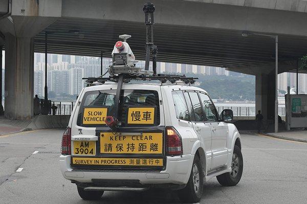
The Vehicle Mobile Mapping System, comprised of five pieces of equipment, works together to collect detailed information for the 3D City Map. (Source: News.gov.hk)
The mentioned equipment includes a high-resolution camera that captures 360-degree images and a 3D laser scanner that collects spatial measurements. These are mounted to rugged and sturdy vehicles that weave and move throughout the city, compiling and renewing information to provide the most complete and accurate model possible. The system also uses an inertial navigation system, a distance measurement indicator, and a global navigation satellite system receiver to provide precise positioning of the equipment. Drones are also used to provide a map of the city that complements the information gathered by the Mobile Mapping System at the ground level.
The 3D mapping system has allowed Hong Kong authorities to plan and visualize the dense urban environment in a faster and easier way. The tool caters to the needs of a greying population amid the rising demand for urban redevelopment. The system also effectively acts as a one-stop portal, embedded with all kinds of data ranging from population trends to building heights, which allows for a preliminary analysis of how a proposed building could impact the neighboring environment, with assessments on matters such as air ventilation and even whether a new structure would affect the view of neighboring blocks.
Milestones
In 2020, the Hong Kong Lands Department’s Vehicle Mobile Mapping System became a finalist in the Urban Planning and Land Use category at the Smart City Asia-Pacific Awards (SCAPA). The following year, the Hong Kong Lands Department initiated the creation of a 3D Indoor Map for 150 buildings in the Kowloon East area. This included unit-based information and routing designed to support different potential applications. Feedback from different stakeholders will be collected and used to further enhance the 3D Indoor Map of an additional 1,250 buildings by the end of 2023. Major landmarks and government facilities accessible to the public will be given priority for inclusion in the upcoming list.
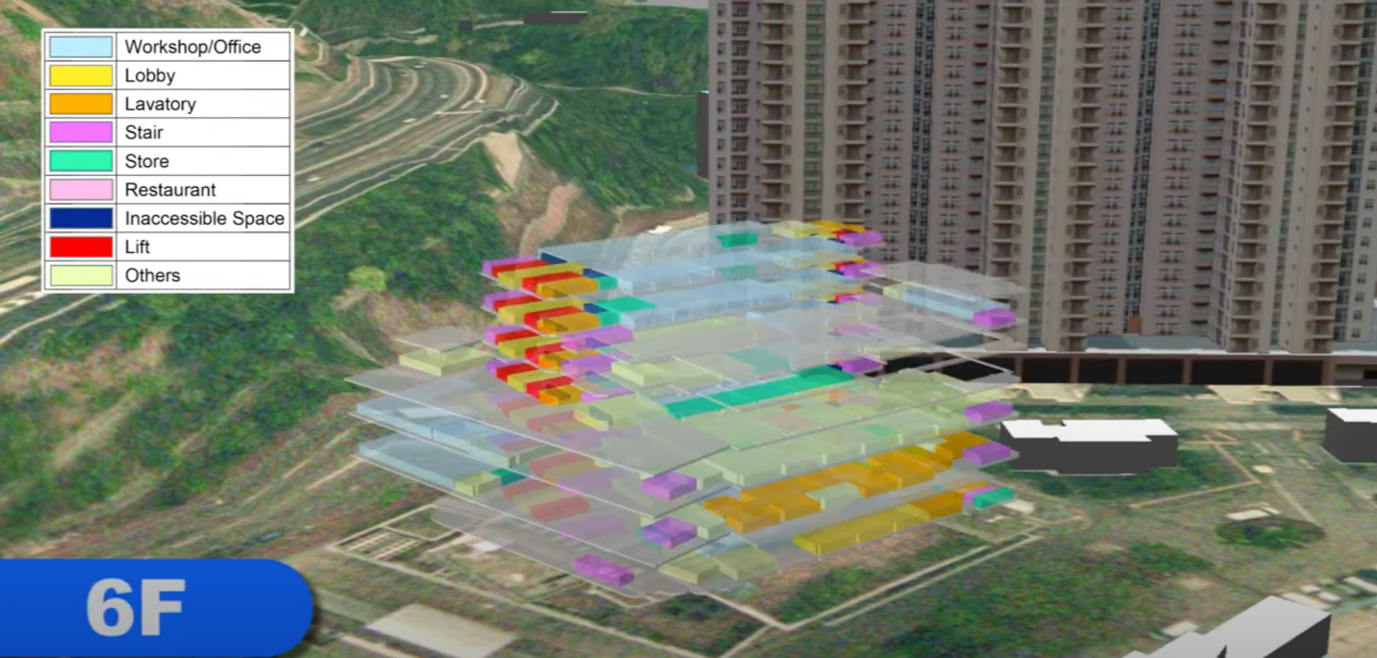
Sample of Indoor Mapping (Source: Hong Kong Lands Department)
Photos
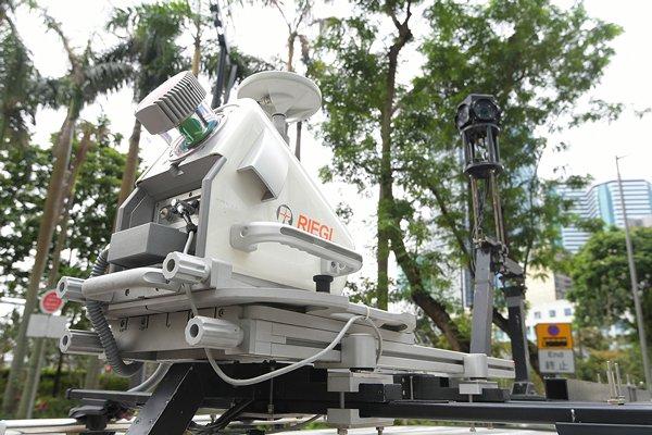
A 3D laser scanner on top of the vehicle collects spatial measurements and a high-resolution camera captures 360-degree images. (Source: News.gov.hk)
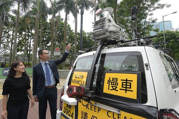
One of the system’s biggest advantages is its ability to quickly and efficiently acquire data, which can be used to enrich 3D models. (Source: News.gov.hk)
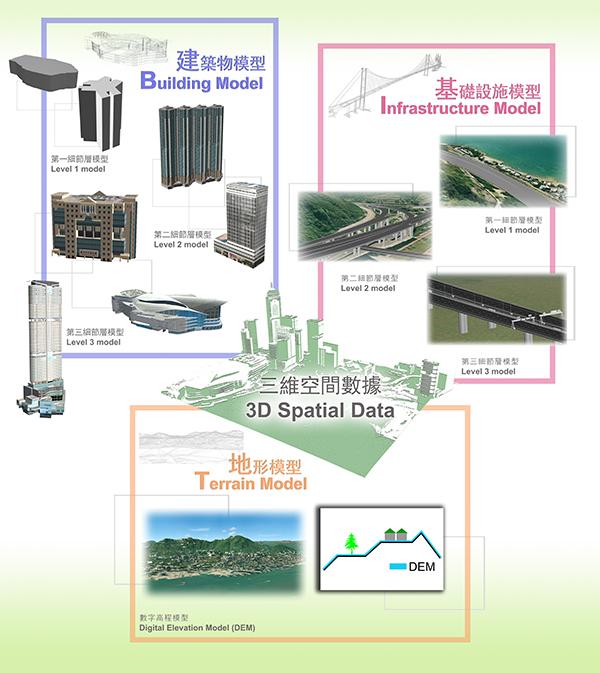
Illustrating Different Classes of 3D Spatial Data (Source: Hong Kong Lands Department)

A view of Hong Kong Island Generated Using 3D Spatial Data (Source: Hong Kong Lands Department)
Sources
Chu, A., & Fan Ko-kwan, B. (2021, June 21). Development of the 3D Digital Map in Hong Kong. FIG e-Working Week 2021. Retrieved December 3, 2021, from https://www.fig.net/resources/proceedings/fig_proceedings/fig2021/papers/ts03.3/TS03.3_yik_fan_11201.pdf.
Hui, E. C. M., & Yu, K. H. (2009, January). Residential mobility and aging population in Hong Kong. Habitat International, 33(1), 10–14. doi:10.1016/j.habitatint.2008.02.001
IDC (n.d.). IDC Smart City Asia Pacific Awards 2020 Finalists. IDC Official Website. Retrieved from https://www.idc.com/ap/smartcities/2020-finalists/
3D mapping unlocks a new world. (2019, November 10). News.gov.hk. Retrieved from https://www.news.gov.hk/eng/2019/11/20191108/20191108_141157_575.html.
Sharon, A. (2019, November 14). HK’s 3D Mapping Tech Pushing Smart City Goals. OpenGov Asia. Retrieved from https://opengovasia.com/hks-3d-mapping-tech-pushing-smart-city-goals/.
The Government of the Hong Kong Special Administrative Region. (n.d.). 3D Mapping. Lands Department. Retrieved from https://www.landsd.gov.hk/en/survey-mapping/mapping/3d-mapping.html.
Smart vehicle roams Hk to create 3D maps. (2019, November 11). The Standard. Retrieved from https://www.thestandard.com.hk/sections-news-print/213397/Smart-vehicle-roams-HK-to-create-3D-maps.
Wong, K. & Yeung, M. (2019, January). Economic Letter 2019/02: Population ageing trend of Hong Kong. Office of the Government Economist, The Government of the Hong Kong Special Administrative Region. Retrieved from https://www.hkeconomy.gov.hk/en/pdf/el/el-2019-02.pdf