Title of Productivity and Innovation Initiative:
Enhancing Disaster, Incident, and Traffic Management through Pasig City’s Smart Public Safety Management System Project
Implementing Agency:
City Government of Pasig
Year Implemented:
2016 – present
Themes:
Management for Productivity; Quality and Agility; Digitization & New Technologies
General Description
The initiative consists of multiple Pasig City public safety initiatives integrated in a manner that reduces costs and improves efficiency in providing data and coordinating a response.
Background and Problems
The advent of Typhoon Ketsana (Philippine name: Ondoy) in 2009 left significant economic and social damage to Pasig City and the rest of Metro Manila. This highlighted the city’s vulnerability to natural disasters, as there are three major waterways surrounding the city and a major fault line running through certain parts of it.
The highly urbanized nature of Pasig also means increased risk for man-made disasters such as fire, drowning incidents, vehicular accidents, and medical emergencies. These public safety vulnerabilities constrain the city’s plans for increased urbanization and infrastructure development.
Solution and Impact
With the goals of improving Pasig City’s public safety efforts in the areas of efficiency and sustainability as well as the reduction in resource consumption for incident monitoring and management, the Pasig City government introduced the Pasig Smart Public Safety Management System, whose major components include:
- Computer-Aided Dispatch: Designated as the eC3-CMS, an information system that allows for data analysis and reporting of information in real-time, which is gathered via incident reports by citizens through the Mamamayang Aksyon sa Emergency (MaSE), a free mobile public service application for use in Android and iOS devices.

The interface of the MaSE system (Source: Pasig City DRRMO)
- Adaptive Intelligent Traffic System: A system deployed by the city to optimize the use of road networks in the city with the goal of safer, smarter, and more coordinated traffic flow. This is done via data gathering sensors deployed in critical traffic points in the city, allowing for adaptive control of traffic light times and management of rush hour traffic in a coordinated and real-time manner. The system data is accessible through the Pasig Smart City App, which shows real-time traffic situations throughout the city.
- Flood Awareness Simulation Tool: An tool, used in conjunction with the city’s disaster risk reduction and management plans, which can provide information and run possible scenarios in areas prone to flooding. The simulation software makes use of sensors installed in various high-risk locations in the city to collect data on other environmental concerns such as water pollution and PH level, air quality, humidity, wind direction and speed, noise pollution, and UV index levels.
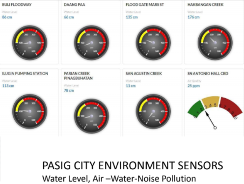
Environment sensors user interface (Source: Pasig City DRRMO)
- GSM Emergency Alert System: The public safety system utilizes an emergency network GSM system that allows for the rerouting of emergency calls to predetermined locations when commercial GSM systems are damaged or compromised. In cases of major disasters, a Text Message Alert System (TMAS) is activated, which would send SMS advisories and notifications to individuals regardless of their chosen commercial GSM network.
The existing infrastructure used in conjunction with these systems includes more than 225 surveillance cameras, solar-powered citywide mass alert sirens, a 24-hour phone and text hotline, and multiple operational pumping stations in 22 flood-prone areas in the city.
All systems mentioned in the Smart Public Safety Management System are managed by their City Command Center (C3), built in 2010. Once the C3 staff is able to verify a report, radio dispatchers coordinate and deploy the nearest responders to incidents. All interactions between citizens and the system are recorded.
Milestones
The Pasig City Smart Public Safety Management System Project was named an outstanding smart city project in the 2018 IDC Smart City Asia Pacific Awards for delivering better urban planning and operational efficiency. The project was one of 19 winners out of 148 smart city projects across 12 functional categories.
Photos

A screenshot from the Pasig Smart City App, a mobile application allowing for localized monitoring of traffic within the Pasig area. (Source: Pasig City Government)
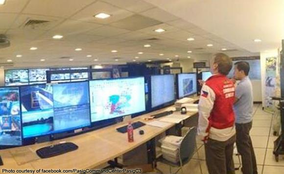
Officials discuss in the Pasig City control room.
(Source: Pasig Command Center Facebook page)
Sources
Jocson, L. C. (2018, July 11). Pasig’s public safety project named one of Asia’s “most outstandingâ€. Rappler. https://www.rappler.com/moveph/pasig-public-safety-included-most-outstanding-smart-city-projects-2018
Lozada, D. (2014, June 18). Pasig City: Learning from Ondoy, ready for the rain. Rappler. https://www.rappler.com/moveph/pasig-city-disaster-management-ondoy
Tuaño, P. A. P., Muyrong, M. S., & Clarete, R. L. (2016). Economic Impact of Typhoon Ondoy in Pasig and Marikina Cities Using a Multiweek CGE Model Analysis. Philippine Journal of Development, 43(2). https://pidswebs.pids.gov.ph/CDN/PUBLICATIONS/pidspjd2016-2_ondoy.pdf