Organization

Tarlac State University

Best Practice Focus Area/s

Citizens / Customers, Human Resource

Year Implemented

2018

This is a GBPR finalist entry

Summary

As an academic institution, the commitment to determine the effectiveness and efficiency of instruction or educational services and its continual improvement for ultimate customer satisfaction is paramount. Tarlac State University (TSU) has computerized the system of evaluating the teaching effectiveness of its faculty members through the Automated Faculty Evaluation System (AFES). It was developed by the university’s Innovation Team (iTSU) through the Public Sector Productivity Innovation Laboratory Project under the Development Academy of the Philippines (DAP).

Background and Problem

Before developing the AFES, TSU implemented a pen-and-paper faculty evaluation facilitated by the HRDMO. Some of the issues and insights of the system were:

  • Evaluation instrument is not easily understandable to students
  • Subjective evaluation due to bias, lack of relevant key performance indicators
  • Exclusion of qualitative factors
  • Disruption of classes due to sit-down observation
  • Not all students evaluate the faculty
  • Physical monitoring is inconvenient, so it is not regularly conducted, and the anonymity of students is not guaranteed.

Regarding the administration of pen-and-paper evaluation, issues encountered were both human and materials-related such as conflicting schedules of faculty and the clients, time management for the limited staff assigned in performance evaluation, and the timeliness of reports submitted to the authorities for proper action or intervention. Hence, the objective of the Automated Faculty Evaluation System is to address these issues and concerns for utmost customer satisfaction and consistent delivery of quality instruction services by the faculty members.

Solution and Impact

The university’s Innovation Team (iTSU) developed the system through the Public Sector Productivity Innovation Laboratory Project under DAP. The project underwent two phases before its implementation.

  • First Phase: Design and Conceptualization to automate the handy evaluation tool by the NBC 461 QCE Teaching Effectiveness Instrument for Client Rating used for faculty upgrading, reclassification, and promotion.
  • Second Phase: Collaboration between the HRDO and MISO for development and implementation. Before implementation, a series of presentations and consultations were done with the students, academic affairs, faculty and personnel union, council of deans, administrative and academic council, and other stakeholders. Orientation was also conducted for students to familiarize themselves with TSUA-FES. The pilot run was Beta tested during the First Semester of the Academic Year 2018-2019 and officially commenced the succeeding semester after deliberation by the Vice President.

The TSU-AFES is implemented across all ten colleges on three different campuses. It is linked to the university’s student portal, where all students have accounts and are given equal opportunity to evaluate their instructors/professors. It is also linked to the employee portal for pinning the evaluation schedule and generating the report by the HRDMO.

Through the implementation of the AFES, TSU has achieved zero class minutes interrupted per semester with an equivalent amount of Php 24,750.00 per semester, a reduction in workforce deployment of 14 HRDMO staff, and savings of 113 working days per semester. Student engagement and participation improved by 79.38%, and evaluation results were expedited from six months to seventeen days. Some of the long-term impacts include the following:

  1. Basis for Curriculum/ Program Enhancement;
  2. Basis for long-term academic plans, facilities improvement, and enhancement of student affairs services;
  3. Recognition scheme of good performance;
  4. Influenced the atmosphere of positive feedback mechanism;
  5. Programs for Faculty Development, coaching, and mentoring programs by immediate supervisors; and
  6. Provision of Commendation letters from HRDMO given to all faculty members after the rating period (commendation, offering of HR services–counseling, coaching, and mentoring).

Milestones/Next Steps

  1. TSU-HRMDO gained acclaim as the only university in the Philippines to be certified PRIME-HRM Maturity Level 2 in all four areas of Recruitment Selection and Placement (RSP), Performance Management (PM), Learning and Development (L&D), and Rewards and Recognition (R&R) in the whole Region 3, alongside local government units in 2017.
  2. TSU leveled up with its accomplishment when the Civil Service Commission–Central Agency validated the National Level PRIME-HRM Bronze Award received by TSU during the HR Symposium in July 2019. A quarter of the recognition was attributed to the Performance Management System of TSU.
  3. Enhanced student and faculty performance as evidenced by the Licensure Examination Performance of the university.
  4. 100% accreditation of university programs by the Accrediting Agency for Chartered Colleges and Universities of the Philippines (AACCUP);
  5. PBB qualifier for three consecutive years–2016 to 2018, 2019 pending result; and
  6. The university was granted SUC Level 3 by the Commission on Higher Education (CHED) and Institutional Accreditation level II by AACCUP.

Organization

Eastern Visayas Health Research and Development Consortium- Leyte

Best Practice Focus Area/s

Strategy, Operations

Year Implemented

2011

This is a GBPR finalist entry

Summary

The practice unique to the Eastern Visayas Health Research and Development Consortium (EVHRDC) is called “Pioneering Public-Private Partnership Towards Sustainable Eastern Visayas Health Research & Innovation (4Ps TSEVHRI)”. This strategy enables the consortium to conduct activities needed to generate more health-related proposals, such as live-in training on Basic Research Methods (BRM) and Research Proposal Enhancement Workshops (RPEWs). The partnership of the Department of Health (DOH) EVCHD and DOST Regional Office (RO) VIII with the rest of EVHRDC’s member institutions significantly contributed to more research activities, which resulted in the highest number of consortium-funded health research based on the Regional Unified Health Research Agenda (RUHRA) compared with other Regional Health Research and Development Consortiums (RHRDCs). Adhering to the EVHRDC‘s vision as a transformative consortium, the consortium developed and disseminated evidence-informed policies adequately. These include the policy note “Improving Sanitary Conditions and Food Handler Practices Among School Canteens in Eastern Visayas” and a policy brief titled “The Seasonal Pattern of Occurrence of Aedes Aegypti by Larvitrap Surveillance,” which were based on the results of EVHRDC-funded research.

Background and Problem

In Region VIII, an increasing number of health research proposals are submitted to the consortium for funding consideration per year based on the number of proposals reviewed by the consortium’s RMC and ERC. There is also an increasing number of EVHRDC member institutions. The consortium’s series of activities, particularly to address the training needs of researchers, continue to increase every year to capacitate them further. When a researcher submits a capsule proposal identified with the region’s health priorities, the researcher is invited to attend a live-in Basic Research Methods (BRM) training. The researcher is endorsed to several Research Proposal Enhancement Workshops (RPEWs) until the paper becomes a full-blown proposal ready for funding.

The ExeCom, as the overall governing body of the consortium, discusses all administrative and operational concerns. The RMC meets to discuss affairs concerning planned, ongoing and concluding research projects. The consortium also has six (6) committees, meeting at least once every quarter. The ERC reviews research proposals and ensures that research in the region follows international and national guidelines, local laws, professional conduct and practice standards, community moral values, and needs.

The RUC is in charge of disseminating the research results to stakeholders. The CBC is responsible for building member institutions’ capability to engage in research activities and form institutional partnerships. The SOME handle concerns regarding institutions’ membership, hiring secretarial staff, and selecting committee chairs and members.

Solution and Impact

The consortium’s increasing number of activities, which subsequently increases in the number of research proposals for funding, has posed a challenge for the consortium. Moreover, the number of representatives from member institutions that comprise the different committees is also increasing. Thus, more workforce support is needed under the secretariat. Although the DOST-PCHRD provides funds for the consortium’s operation and research grants, the increasing demand for research funding has prompted the consortium to develop a strategy to address this challenge.

Later, the funds were downloaded every year to DOST-RO VIII, where the EVHRDC Secretariat is lodged. Both DOH-EVCHD and DOST-PCHRD now fund proposals submitted to the EVHRDC. Together with member institutions, all consortium activities are strongly collaborated by DOH-EVCHD and DOST-RO VIII. Both offices share the operational expenses in addition to PCHRD’s fund.

The number of consortium activities increased dramatically in 2015 after the DOH-EVCHD began funding research studies. This further strengthened and sustained the collaboration and cooperation among member agencies and stakeholders. The different committees began working together toward one goal: to help researchers fund their studies and advocate and support the health research culture in the region. Every year, the consortium conducts more activities to reach its goals.

Since there were more activities to help researchers generate capsules and full-blown proposals, the number of proposals reviewed increased yearly. The consortium received fewer proposals in 2014 after super typhoon Yolanda hit the Region in November 2013. However, the consortium remained resilient, like the people of Region VIII, and even intensified efforts to call for proposals to receive and fund more health research. In 2015, a few years after the 4Ps TSEVHRI was implemented, RMC and ERC showed an increasing trend in the number of proposals reviewed.

The EVHRDC has seen an increase in the number of proposals funded starting in 2015 due to the strong partnership between DOH-EVCHD and EVHRDC and more funds allocated for health research. As the number of staff, activities, and proposals reviewed increased after DOH-EVCHD provided counterpart funds, the EVHRDC attained one goal: to mobilize and complement health research resources to generate knowledge and products in health. They have conducted more training to capacitate regional researchers further, thus helping them develop more health-related proposals. As a result, another goal was to increase research productivity aligned with the priority program.

Milestones/Next Steps

Aside from the counterpart funds for research operations shared by the two agencies, DOH-EVCHD downloads separate funds purely for research grants and hiring additional personnel to support EVHRDC operations, increasing the consortium fund base.

  1. From 2010 to 2014, EVHRDC had only one project staff who acted as the secretariat and the Project Coordinator. With the counterpart funds provided by DOH-EVCHD to the consortium, one (1) additional staff was hired to ensure that the consortium had enough staffing to conduct all its activities.
  2. From 2011 to 2019, the consortium funded twenty-five (25) health research with total funding of Php 6,567,085.00 from PCHRD and Php 8,903,373.80 from DOH. It is one of the two (2) consortia with its Manual of Operations (MOO).
  3. In 2018, the Consortium also received awards during the 12th PNHRS Week Celebration, namely:
    • Best Consortium Poster –1st place
    • CBC Best Practice Poster Contest –3rd place
    • Oral Contest- Professional Category –3rd place
  4. This best practice started in 2011 when DOH-EVCHD provided counterpart funds for EVHRDC to fund approved health research in the region
  5. Aligned with the Philippine National Health Research System (PNHRS) Strategic objective, which is to increase the financial and other resource commitment for health research, DOH-EVCHD, with its initiative as the consortium chair, allocated funds for research activities and research grants starting in 2011.
  6. The EVHRDC participated in the 13th Philippine National Health Research System (PNHRS) Week Celebration on 13-16 August 2019, at Limketkai Luxe Hotel, Cagayan de Oro City, with the theme, “Achieving Health-related Sustainable Development Goals (SDGs) through Research and Innovation,” where EVHRDC bagged home three different awards, as follows:
    • 3-Minute Pitch to Policy Makers –3rd place
    • Oral Research Contest (Student Category) – 2nd place
    • Consortium Poster Exhibit Contest –2nd place
  7. The EVHRDC participated in the First Health Research Forum for Action in the Visayas on 25-27 September 2019, at Eon Centennial Resort Hotel & Waterpark, Alta Tierra Village, Jaro, Iloilo City, with the theme “Going LOCAL for UHC: Realizing Universal Health Care through Evidence-Informed Service Delivery.” There were two (2) competitions, and EVHRDC received the first place award for both, as follows:
    • 3-Minute Pitch Contest –1st place
    • Poster Exhibit Contest –1st place
  8. As of 2020, the consortium maintains four (4) detailed staff for the secretariat and is assigned to handle different committees
  9. The EVHRDC Ethics Review Committee (ERC) was awarded Level II accreditation by the Philippine Health Research Ethics Board (PHREB) in 2016 and has already renewed its accreditation from May 29, 2020, to May 28, 2023. The ERC also has its Standard Operating Procedures (SOP) and office, wherein all research protocols reviewed by ERC are coordinated.

Title of Productivity and Innovation Initiative

Guagua Geographic Information System (GGIS)

Implementing Agency

Municipal Government of Guagua, Pampanga

Year Implemented

1997-Present

Themes

Management for Productivity, Quality and Agility, Digitization & New Technologies, and Perspectives on Productivity, Governance, and Development

General Description

The Municipal Government of Guagua is one of the first LGUs in Region III that started the development of a Geographic Information System (GIS.) Through the assistance of the Australian Agency for International Development (AusAID) and the Philippine Land Information System, the Guagua Geographic Information System (GGIS) project was first launched in 1997. The GGIS spatial maps and database is widely used in Comprehensive Land Use Planning (CLUP), local disaster risk management, traffic management, and the administration of tax programs such as land valuation and land use. At present, it is continuously being updated by the Office of the Municipal Planning & Development Coordinator (MPDC).

Background and Problem

The geographic location of the Philippines makes it a disaster-prone country, as it regularly faces natural hazards such as typhoons, flash floods, landslides, earthquakes, and volcanic eruptions. This state of affairs is expected to intensify in severity and impact in the coming years due to climate change, continually hampering the economic development of the country and causing widespread destruction of resources and property. The 1991 eruption of Mount Pinatubo in particular has taken a serious toll on the people of central Luzon, displacing more than 10,000 families and dramatically altering the landscape of the area, thus necessitating an updated mapping system for preventive planning and action.

The Municipal Government of Guagua, Pampanga, is located along the Pasig Potrero River Control System (PPRCS), one of Mount Pinatubo’s main river channels, thus making the residents vulnerable to any further volcanic activity. Apart from this, land tax management, such as determining the exact figure area, is also one of the challenges since the municipality has over 10,000 parcels in just 4,875 hectares.

Solution and Impact

At present, the most frequent use for GGIS is to provide land developers and property owners with land use information, as these form the basis for property rights. The usual requested information varies in terms of property location, dimension, existing owners’ name, property rights, previous owners, missing and erroneous lots, values, and many other categories of spatial data. This removes the need to do research at the Land Management Services (LMS) since most data are available in the municipal office.

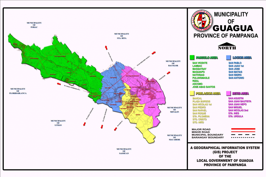
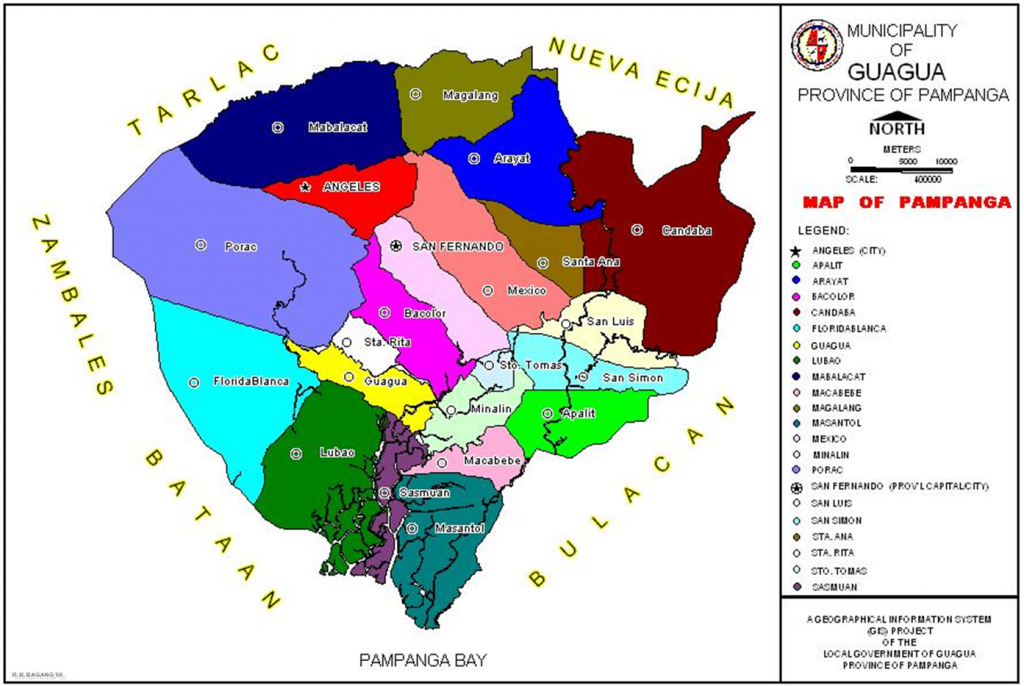
2021 GIS Map of Guagua

The GGIS can also be used to provide efficient and accurate tools for collecting, storing, retrieving, reporting, and displaying public information. The passage of a Sangguniang Bayan Ordinance through the local revenue code to collect minimum fees has helped augment the research activities of the MPDC Office.

For disaster response, thematic GIS mapping serves as an important tool to identify flooded barangays, risk areas, affected utilities, road accessibility, and possible lifelines and exit routes. In regular disaster preparedness activities, data are likewise presented in GIS format, making the discussions and planning more accurate and visually understandable.
To address resource and land use issues, GGIS is utilized to identify and analyze the development of the town’s land resources, support the preparation of land use plans for environmental regulatory programs, determining the best location for the proposed environmental projects such as landfills and material recovery facilities, identifying lots for reclassification purposes, capturing lot data for tax assessment and identification, maintaining property records, zoning, traffic management and rerouting, and tracking down encroachments, particularly along river channels.

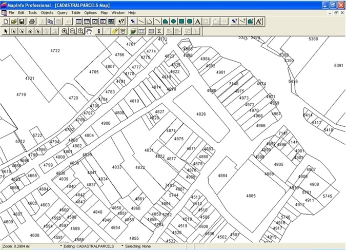
The applications of GGIS for Guagua have also expanded to include land registration and cadastre, transportation, risk management, resource, and land use issues in the local government functions. The area of land registration and cadastre is one of the most interesting areas in the use of GGIS and Land Information System.

2021 Parcellary Map of Guagua

Milestones

Out of a total of 108 LGU-initiated programs that participated in the 2020 Digital Governance Awards, the Department of the Interior and Local Government recognized 15 LGUs for making significant changes to improve their public service delivery amid the COVID-19 pandemic. The Municipality of Guagua, Pampanga was the champion under the category Best in LGU Empowerment (G2G) for GGIS.

To date, the GIS unit is housed in the MPDC office. Although the GIS project is not a priority of the administration, data collection and encoding are continuously undertaken despite the limited funds. The office has coordinated with the Lands Management Bureau RO3 to acquire photocopies of new subdivision lot plans and with the Registry of Deeds RO3 to provide copies of all new approved titles. Although it is not equipped with a plotter, the office could produce 1:4,000- and 1:2,000-scale maps of the town by printing them in regular bond papers then cutting and connecting all the portions. These scaled, hardcopy maps are used to identify missing lot data, overlapping lots, and barangay boundaries with much or reasonable accuracy.

2021 CLUP Map of Guagua

At present, 98 percent of all lot data, subdivision lot plans, and mother titles have already been encoded. With almost completed spatial data, the identification of barangay boundaries is being undertaken, based on existing cadastral lot boundaries, mapping boundaries, and Transfer Certificates of Titles. Since these three show different barangay boundaries, the concerned barangay councils are encouraged to negotiate amiably on the issue of barangay boundaries.

References

Bautista, C.B. (1999, October 06). The Mount Pinatubo Disaster and the People of Central Luzon. USGS Publications Warehouse. https://pubs.usgs.gov/pinatubo/cbautist/

Chavez, C. (2020, December 15). DILG Commends 15 LGUs for their digital governance solutions. ManilaBulletin. https://mb.com.ph/2020/12/15/dilg-commends-15-lgus-for-their-digital-governance-solutions/

Municipality of Guagua. (2010). Guagua Geographic Information System (GGIS) 2010. https://fdocuments.in/reader/full/guagua-clup

Vincenzo Bolletino et al., (2018). Perceptions of Disaster Resilience and Preparedness in the Philippines. Harvard Humanitarian Initiative. https://hhi.harvard.edu/publications/perceptions-disaster-resilience-and-preparedntess-p

Title of Productivity and Innovation Initiative

Geohazard Mapping Information System

Implementing Agency

City Government of Cebu

Year Implemented

2000-Present

Themes

Technology, Disaster Risk Reduction and Management

General Description

Cebu City experiences a substantial number of geohazards. Also, prior to any intervention, their disaster management had mostly been focused on response and has been quite lacking in mitigation or preparation. Because of this, the LGU expanded its Geographic Information System (GIS) to create the Geohazard Mapping Information System (GMIS). Initially, the GIS had limited features that could only be used for land use planning, subdivision review, and tax mapping, but the functionality of the GMIS has been expanded to include preparing and responding to disasters at all levels. Particularly, the GMIS excels in providing information regarding key geohazard concerns and it has since aided them in implementing disaster resilient projects, especially those concerning infrastructure.

Background and Problems

Cebu City has its fair share of both natural and man-made geohazards, such as storms, floods, landslides, tornadoes, earthquakes, fires, and even epidemics. However, before the Cebu City LGU’s Local Disaster Risk Reduction Management Office (LDRRMO) had the GMIS, much of their efforts had only been concentrated on response, reconstruction, and restoration. Because their maps before the GMIS did not yet contain the necessary information, they had not been able to fulfill their responsibilities in disaster mitigation.

A notable example of this deficiency in mitigating disasters was evident in their handling of the city’s informal settlers, who used to build illegal structures along rivers, creeks, and sidewalks. These structures have cumulatively reduced the capacity of these waterways, making them narrower and shallower. Because of this, the flow of floodwater would recede slower even in low rainfall, thus causing floods around the area of SM City Cebu and some of the barangays in the city proper. It would often be the case that the same informal settlers were also the first to be affected by these floods.

Although the Cebu City LGU did implement an ordinance requiring three meter easement along waterways to mitigate this issue, they still had to spend a substantial amount of time finding temporary evacuation centers and relocation sites for the informal settlers. Particularly, LDRRMO staff had to manually go to sites and negotiate with barangay officials or private owners about placing evacuation centers and relocation sites in their premises.

Solution and Impact

In 2000, the Cebu City LGU’s GIS staff and LDRRMO staff formed a team to conduct comprehensive field surveys using GPS equipment. The survey data was overlaid on existing maps in their GIS and complemented with historical disaster data to create the initial GMIS. In line with geohazard monitoring, the local government also installed 35 CCTV cameras at strategic places and intersections of the city. And shortly after implementation, even barangay officials had also been involved in conducting field surveys to keep the geo-hazard maps updated.

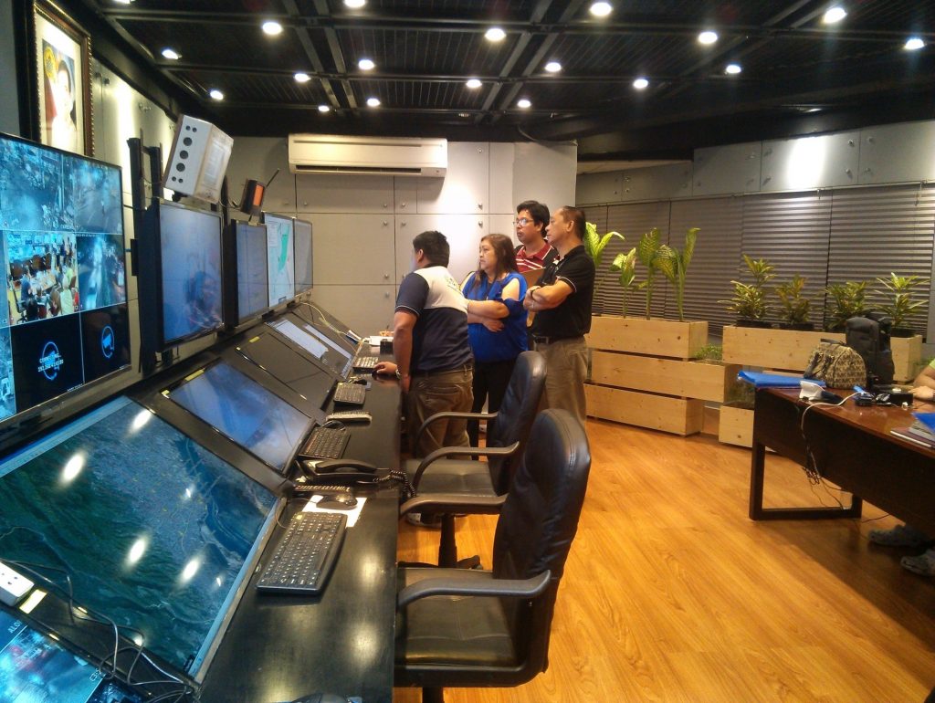
Cebu City Command Control Center (C3)

The GMIS has since acted as a source of readily available information for key geohazard concerns like:

  • Heavily populated communities
  • Coastal areas that are not easily accessible
  • Old roads, bridges, creeks, drainages, and buildings
  • Bodies of water that could be potential mosquito habitats
  • Areas that could be affected by sea-level rise and storm activity
  • Shapes and contours of lands for understanding the flow of water
  • Areas prone to fire
  • And many more

These kinds of data have been useful for their disaster response, reconstruction, restoration, and even mitigation—something they had been lacking in initially. This emphasis on disaster mitigation has allowed the GMIS to make some notable contributions to the city’s strategic development, particularly around the development of infrastructure and city planning.

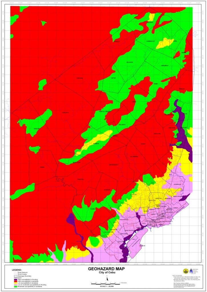
Cebu City Geohazard Map

For example, In 2013, the planning for the Cebu City LGU’s Bus Rapid Transportation (BRT) project was conducted with the aid of the GMIS. Through the GMIS’s aerial photos, an efficient and disaster resilient bus route was identified.

And in 2014, the GMIS aided in the implementation of the LGU’s Reblocking Project. The reblocking aimed to provide wider roads for fire trucks, rescue vehicles, and police forces to have easier access to interior residential and commercial areas. The project cost PHP 35,000,000 and consisted of road widening, drainage construction, inspection of electrical connections, and the relocation of affected families. In this project, the GMIS was able to identify seven key high-population barangays for the project. It was also able to contribute to the efficient allocation of resources by providing information on areas that were most prone to flooding. This had led the project team to identify the necessary roads to widen easily.

The tool has also aided the LGU in many other ways. For instance, it contributes to the crafting of the city’s annual Disaster Management Plan. Notably, it is 5% of the city’s total annual budget. And given the budget’s size, the GMIS has never been more important to ensure proper planning of resources. Also, it has been useful for conducting disaster awareness and preparedness education campaigns in all 80 barangays of the city. Through the tool, each barangay can be provided with maps showing disaster-prone areas within their barangay.

Cebu City Command Control Center (C3)

Also, the GMIS has benefited not only the city at large, but also the people who work towards the betterment of the city. Notably, before the GMIS, the time it took for Cebu City’s Department of Engineering and Public Works (DEPW) field engineers to estimate the lineal meters of culverts was two to three days. Now using coordinates from the GMIS, it now only takes 20-30 minutes.

Milestones

In 2018, Cebu City was chosen as one of the six winning local government units in the Digital Cities Philippines (DCP) Awards Night because of their Geohazard Mapping Information System. This project was awarded the title “Best Data-Driven Governance (D2G)” (SunStar Cebu, 2018).

According to an interview in October 2021 with Engr. Conrado Ordesta III, assistant department head of the Management Information Computer Services Department under the Cebu City LGU, the GMIS has also been useful beyond just geohazards, as it has also been useful in tackling the COVID-19 pandemic. Through the tool, Cebu City LGU’s could also monitor and visually plot the pandemic and the status of vaccinations throughout their city. Notably, they identified key areas that had low vaccination rates and thus were able to implement more targeted interventions, house-to-house vaccinations. He mentioned that this was even able to bring their vaccination rates above 50%.

Testimonials

In the same interview, Engr. Conrado Ordesta III mentioned that many of its users are happy with the project. Notably, he mentioned that their Fire Department has extended much gratitude to them as they can now respond more quickly, they now know where to station themselves more effectively, and they also now have a reference for where “wet” and “dry” fire hydrants are.

He has also observed that their rescuers are now more able to take proactive preparations for disasters, especially for landslides. He mentioned that a limitation they had before was their Disaster Office being in their city proper, yet many of their mountain-based barangays are the ones experiencing landslides. But through their GMIS, they had been able to put up satellite offices and evacuation areas at strategic locations.

Sources

Cacho, K. O. (2018, October 17). Cebu LGUs win big in digital cities ph. SunStar Cebu. Retrieved November 5, 2021, from https://www.sunstar.com.ph/article/1769659/Cebu/Business/Cebu-LGUs-win-big-in-Digital-cities-PH.

Implementing Agency

Jakarta Provincial Government and Jakarta Smart City Management

Year Implemented:

2017 – present

Themes:

Management for Productivity; Quality and Agility; Digitization & New Technologies; Perspectives on Productivity, Governance, and Development

General Description

Developed by Jakarta Smart City Management, Jakarta Citizen Relationship Management (CRM) Application is a mobile application that streamlines public services management and citizen action from the Jakarta Provincial Government.

Background and Problems

In a megacity like Jakarta, where over 200 government agencies operate, the task of managing and resolving citizen complaints is a daunting task, complicated by multiple initiatives that require consolidation and immediate response.

Beginning in the latter half of 2010, improvements in online applications led to increased citizen engagement and enhanced institutional responsiveness from the local government. Initial efforts in Jakarta resulted in the 2014 launch of the application “Qlue,” an integrated citizen reporting system that subsequently led to improved response times from local government services. The app opened the door for better engagement with the local constituency, and the Jakarta municipality saw overwhelmingly positive results, including a 94% reduction in possible flood areas, a 61.4% boost in government efficiency, and a 47% rise in public confidence.

However, the success of Qlue as a communicative and inclusive avenue for citizen engagement was short-lived. By 2017, the number of complaints registered in the app had dropped significantly as a result of a systematic shift that reduced the daily reporting of data gathered from citizens from three times a day to just once a day, decreasing the potential for civic participation.

Solution and Impact

In 2017, the Jakarta provincial government launched the Citizen Relationship Management App (Cepat Respon Masyarakat) as part of the renewed efforts to replicate Qlue’s success. The platform consolidated 14 citizen complaint channels, including Qlue, that were being used throughout Jakarta’s regional units to process reports. The app was developed by the Jakarta Smart City Management that is responsible for facilitating and streamlining the follow-up reports of citizens who utilize official channels.

The app is considered a bridge between citizens and the government that allows for the resolution of all non-emergency problems in the province. The idea is for citizens to feel that their concerns on issues such as waste management, floods, traffic, and inappropriate public advertisements are being heard and acted upon by the local government with a sense of urgency.

The way reports are being handled by the respective institutions requires that initial coordination is accomplished within a maximum of six hours, and reports are to be submitted within a maximum of seven days. The local government would then act upon these escalated reports through follow-up action via the relevant district receiving the appropriate tasks. Every village in Jakarta has a community complaint dashboard that can be monitored through the app, further improving citizen engagement while also allowing regional working units to better coordinate and work together towards resolving city problems, shortening complaint resolution time, and reducing citizen complaints. Public complaints can also be served through village offices, sub-district offices, city halls, correspondence, or the inspectorate.

The long-term goal of the CRM platform is to fast-track the digital transformation of the public service governance model in Jakarta in a way that is clean, transparent, and citizen-focused.

Milestones

According to the Jakarta government, the number of escalations ranges from 12,000 to 15,000 in any given month, with an 83-86% completion rate. From January 2018 to September 2019, the platform recorded 1,886,685 reports completed, resulting from an average of 673 reports accomplished per day. The app remains in active use, as in March 2021 it was reported that there were 13,312 escalations submitted and 98.83% or 13,156 of those escalations were completed within 26.85 hours.

Jakarta Governor Anies Baswedan emphasized that through this development, it will be easy to identify and appraise performance based on reports, proposals, or complaints from the public.

The project was recently recognized as one of the finalists in the 2020 IDC Smart City Asia Pacific Awards, under the Civic Engagement category, as recognition for its innovative use of technology to solve real operational challenges.

Photos

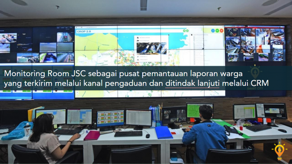
A monitoring room for CRM concerns (Source: Jakarta PR Office)
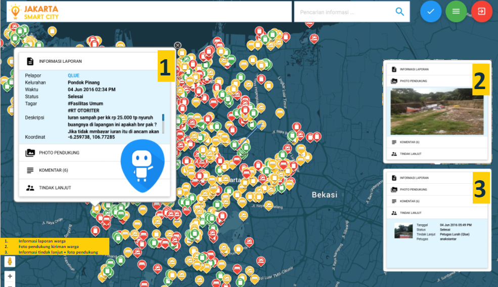
Real-time screenshot of citizen concerns through the Qlue App as consolidated by the CRM platform (Source: Jakarta PR Office)

Sources

Bhwana, P. G. (2019, November 3). Jakarta Continues its Growth into Smart City: JSC Program Leader. Tempo.Co. https://en.tempo.co/read/1267731/jakarta-continues-its-growth-into-smart-city-jsc-program-leader

IDC (n.d.). IDC Smart City Asia Pacific Awards 2020 Finalists. IDC Official Website. https://www.idc.com/ap/smartcisties/2020-finalists/

Salsabila, L., Dzinnun, Y., Nurmandi, A., & Purnomo, E. P. (2020). Citizens Relationship Management (CRM) in Jakarta: Does its work or not? Ijd-Demos, 2(3). https://doi.org/10.37950/ijd.v2i3.64

Tobing, A. G. L. (2021, April 28). Data Cepat respons Masyarakat: Kolaborasi Warga Dan Pemprov DKI Jakarta selesaikan 13.156 Laporan Pada Maret 2021. http://www.beritajakarta.id/. Retrieved October 8, 2021, from https://www.beritajakarta.id/read/88869/data-cepat-respons-masyarakat-kolaborasi-warga-dan-pemprov-dki-jakarta-selesaikan-13156-laporan-pada-maret-2021#.YWAAZNpBw2w.

Mayor Rex Gatchalian of Valenzuela City, Philippines, shared the city’s integrated business permit application system with the participants of the online Trainers Training on Government Digital Services conducted by the Asian Productivity Organization (APO) and the Development Academy of the Philippines (DAP)  on November 26, 2020.

The Paspas Permit is a 10-second business permit application system that allows the issuance of provisionary business permits within ten seconds after confirmation of payment. Before this project, the issuance of business permits at the City Hall takes about 15 to 30 minutes.

The “Paspas Permit” accelerated Valenzuela’s digital technology adoption and streamlined services for more than 18,000 businesses in the city.

Mayor Rex said that “the platform demonstrates the local government’s commitment to making services more efficient and innovative, which in turn can attract more investors and spur further development. The system also integrates services of the Office of the Building Official, City Assessor’s Office, the Local Civil Registry, and the Treasurer’s Office.

The training attended by 27 participants from 10 APO member countries introduced digital services’ role in increasing the effectiveness and efficiency in meeting public needs and identifying the e-government systems that promote quality governance and innovation.