The APO Center of Excellence on Public Sector Productivity
Philippine Standard Time:
Category: Innovation Leadership
Mayor Rex Gatchalian of Valenzuela City, Philippines, shared the city’s integrated business permit application system with the participants of the online Trainers Training on Government Digital Services conducted by the Asian Productivity Organization (APO) and the Development Academy of the Philippines (DAP)Â on November 26, 2020.
The Paspas Permit is a 10-second business permit application system that allows the issuance of provisionary business permits within ten seconds after confirmation of payment. Before this project, the issuance of business permits at the City Hall takes about 15 to 30 minutes.
The “Paspas Permit” accelerated Valenzuela’s digital technology adoption and streamlined services for more than 18,000 businesses in the city.
Mayor Rex said that “the platform demonstrates the local government’s commitment to making services more efficient and innovative, which in turn can attract more investors and spur further development. The system also integrates services of the Office of the Building Official, City Assessor’s Office, the Local Civil Registry, and the Treasurer’s Office.
The training attended by 27 participants from 10 APO member countries introduced digital services’ role in increasing the effectiveness and efficiency in meeting public needs and identifying the e-government systems that promote quality governance and innovation.
Mayor Trina Firmalo-Fabic of the Municipality of Odiongan, Romblon, talked about Leadership on Local Government Administration amidst COVID-19 Pandemic during the 2021 APO Course on Development of Public-Sector Productivity Specialists on March 5, 2021.
The local government responded immediately by creating the Municipal Task-Force on Emerging Infectious Diseases and implementing the Guidelines on Handling the COVID-19 pandemic. She also highlighted the establishment of the Municipal Contact Tracing Team and working with the Department of Science and Technology to utilize FASSSTER and COVIDKAYA for more efficient and fact-based contact tracing.
Mayor Firmalo-Fabic highlighted that the LGU provided COVID-19 updates consistently via live stream announcements on Facebook with simultaneous broadcasts on a local radio station and television channel and distributed flyers to make the citizens well-informed and assured that the LGU is working during the pandemic. Other initiatives include customized care packages for vulnerable sectors, a mobile lab for persons with disabilities and the elderly, a mobile library for children, psychological assistance, online consultations and prescriptions, and shuttle services for front liners.
At the end of the presentation, Mayor Firmalo-Fabic emphasized that “during this pandemic, the local government learned to ensure a timely initial response, to mobilize the departments and the private sector towards a common goal, to treat the community equally and compassionately, to maintain public trust through transparency and consistency, and to use creative solutions to transform challenges into opportunities.â€
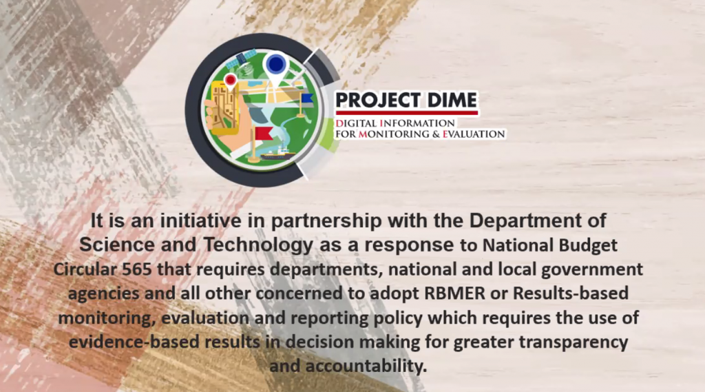
Ms. Jhoana Marie E. Rull, Project Development Officer IV of Project DIME Project Management Office of the Department of Budget and Management, presented the Project DIME (Digital Imaging and Monitoring and Evaluation) during the 2021 APO Course on Development of Public-Sector Productivity Specialists on March 5, 2021.
Ms. Rull mentioned that “Project DIME is a game-changing initiative that utilizes existing technologies for monitoring and evaluation of government projects and at the same time engages in direct dialogue with citizens and civic organizations through participatory monitoring. Initiated by the Department of Budget and Management and Department of Science and Technology, Project DIME is a response to the requirement for departments, national and local government agencies, and all other concerned to adopt Results-based Monitoring, Evaluation and Reporting (RBMER) Policy which requires the use of evidence-based results in decision making for greater transparency and accountability.
Using Digital Data and Imaging Technologies such as Geographic Information System mapping, Google Earth, and satellite images, the initiative monitors government projects classified as (1) hard projects – infrastructure projects that have a horizontal observable output that can be monitored using available technologies; (2) quasi hard projects – infrastructure projects that have a vertical observable output that can be monitored using available technologies and/or actual site visits; and (3) soft projects – programs and projects that have observable non-tangible output.