Title of Productivity and Innovation Initiative

Mauban eLearningVille

Implementing Agency

Municipal Government of Mauban, Quezon

Year Implemented

2011

Theme/s

Digitization & New Technologies

General Description

Mauban eLearningVille is the Technology for Economic Development (Tech4Ed) Center of the Municipal Government of Mauban, Quezon. It was established on September 22, 2011, through Sangguniang Bayan Resolution No. 08-2011, as a Public-Private Partnership Program of the Mauban LGU, Quezon Power Philippines Limited. Co., PLDT, the Department of Science and Technology-Information and Communications Technology Office (DOST-ICTO), National Computer Center (NCC), University of the Philippines Open University (UPOU), the Representative of Quezon Province’s first congressional district, and the Philippine Community eCenter Network, Inc.

Background and Problem

Mauban is a first-class coastal municipality in the northeast section of Quezon Province composed of 40 barangays, 10 of which are located in urban areas. Although the municipal government offers various initiatives to provide quality education for all, ICT education was said to be very limited due to the absence of ICT facilities, equipped trainers, and the lack of access to the Internet. In 2011, several computer shops emerged in the municipality. However, these facilities were not conducive to learning given that most are set up primarily for online gaming. This paved the way for the introduction of the Mauban eLearningVille to address the digital divide and contribute to the digital literacy of residents in the municipality.

Solution and Impact

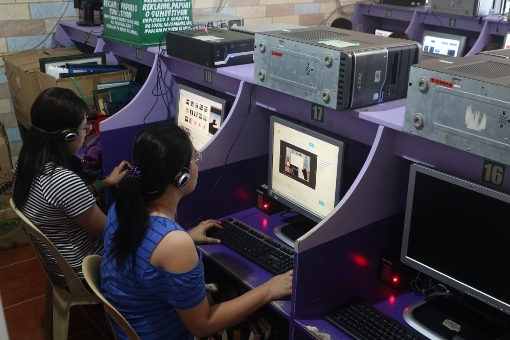
Mauban eLearningVille serves as the ICT hub in Mauban providing constituents with affordable Internet and computer access, ICT skills training opportunities, and free co-working space for webinars and virtual meetings. Most of the clients are barangay leaders, NGOs, and farmers who do not have access to the Internet. The center also conducts basic digital literacy training and various other skills training and seminars, such as English as a Second Language (ESL), MS Office Applications, Adobe Photoshop, and many others. It has helped individuals from different walks of life, including teachers, students, senior citizens, indigenous people, and persons with special needs. Mauban eLearningVille also supports the LGU in developing information, education, and communication (IEC) materials, such as emergency hotline stickers for all households within the municipality, brochures, manuals, and tarpaulin announcements among others.

The Tech4Ed Center also renders other ICT-related services for the LGU. In partnership with the Municipal Agriculture Office (MAO), Mauban eLearningVille facilitates the encoding of application forms of over 1,000 fisherfolks and coconut farmers in the municipality for the Registry System for the Basic Sectors in Agriculture (RSBSA), which is a registry of farmers, fisherfolk, and farm laborers that serves as a basis for the identification of beneficiaries of Bayanihan Act II subsidy and other agriculture-related programs and services of the government.

In partnership with DSWD, the center also helped expedite the printing and distribution of the Social Amelioration Program (SAP) forms to over ten thousand families in the municipality during the pandemic. To enable efficient contact tracing, it also facilitated the processing and issuance of Authorized Person Outside Residence (APOR) IDs for teachers in Mauban who are residing outside the municipality. The center was also in charge of issuing travel clearances, Municipal Inter-Agency Task Force (MIATF) IDs, and BIR forms.

Mauban eLearningVille also supports the Teachers Development Program/En­hanced Continuing Education Program for Mauban (TDP/eCEP4Mauban) of the UPOU, in collaboration with Quezon Power Philippines Limited Co., the Department of Education Division of Quezon Province (DepEd-Quezon), and the UPOU Foundation Inc., which aims to improve the quality of education in Mauban by providing scholarship grants for public school teachers and government employees who desire to pursue graduate studies in UPOU. The center provides facilities for the ICT needs of the scholars and functions as their enrollment and examination center.

To date, Mauban eLearningVille continues to serve as the training arm of the LGU in equipping the unemployed members of the community with relevant ICT skills needed for employment. The ICT skills training in Mauban eLearningVille is recognized by DepEd-Quezon, hence many trainees who successfully completed the course were able to land a job in DepEd immediately, according to Conchita Marta Mirabueno, Tech4ED Center Manager of the Mauban eLearningVille. She explained, “At first, our aim was just to provide quality education among children in Mauban. [Moreover] this program has helped us a lot in the improvement of our livelihood and our career. There are [now] more empowered men and women in the municipality.”

Milestones

Mauban eLearningVille was recognized as an outstanding Tech4Ed Center during the 12th Knowledge Exchange Conference of the Department of Information and Communication Technology in Pasay City in September 2017. In 2016, it received recognition for its more than five fruitful years in service during the 11th Knowledge Exchange Conference held in Quezon City. In 2015, it was awarded the Most Outstanding Community eCenter (CeC) Innovator for iLevel Up Pa More during the 10th Knowledge Exchange Conference in Bacolod. In the same year, the center won 2nd Place in the DigiBayani Award for Digital Literacy by Intel Philippines. In 2012, it became one of the finalists for the Most Outstanding Community eCenter during the 8th Knowledge Exchange Conference in Davao City. In 2013, it was a finalist in the 1st Global Telecentre Awards during the 9th Knowledge Exchange Conference at SMX Convention Center.

Testimonial

“Ang mga magulang ko po ay nangangalakal lamang ng basura, kung hindi po dahil sa eLearning, hindi ko po magagawa ang mga school projects ko dahil wala kaming pera pambayad sa internet shop, dahil po mura sa kanila at bukas araw araw kaya naipaasa ko po ang mga school requirements ko on time”.

Ms. Zara Luma (2016), SHS student

“I had zero knowledge in [using] computer and I joined their 10 days digital literacy for teachers. I used it in my demo teaching when I applied for ranking at DepEd Quezon, luckily, I got a perfect score of 10 because of the knowledge I learned and used during the demo. Now I am a permanent secondary teacher at Dr. Maria D. Pastrana National High School.”

Rhianne Carla M. Gandia (2016), Teacher applicant

“Wala po kaming computer at Internet sa bahay kaya malaking tulong po sa tulad kong estudyante ang eLearningVille. Nakakagawa po ako ng mga research at nakakapag-submit ng assignments and projects dahil open ang eCenter mula 8:00 AM hanggang 9:00 PM. Nabibigyan din po ako ng free access dahil sa madalas kong paggamit ng computer dito sa eCenter. Kaya naman lalong malaking tulong sa ‘kin at sa pamilya ko.”

Nicole Adriano Princess Jade Calleja, Student

References

Aman, J. (2018). (rep.). Mauban eLearningVille Nomination Form.
Mirabueno, C. (2018). Mauban eLearningVille. Quezon; Mauban.

Romualdo, A. (2018, May 2). Making ripples in Mauban. University of the Philippines. Retrieved from https://up.edu.ph/making-ripples-in-mauban/

Municipal Government of Mauban, Quezon. (2018). Mauban eLearningVille. Retrieved from https://www.youtube.com/watch?v=FdItsy5Fr4U&ab_channel=MaubaneLearningVille

Verena, R., & Gelisan, L. (2019, September 2). Teacher development program stakeholders renew partnership. University of the Philippines Open University. Retrieved from https://www.upou.edu.ph/news/teacher-development-program-stakeholders- renew-partnership/

Title of Productivity and Innovation Initiative

Baguio Contact Tracing Ecosystem

Implementing Agency

City Government of Baguio, Benguet

Year Implemented

March 2020-Present\

Themes

Management for Productivity, Quality, and Agility, Digitization & New Technologies, Perspectives on Productivity, Governance, and Development

General Description

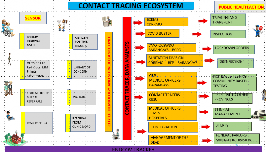
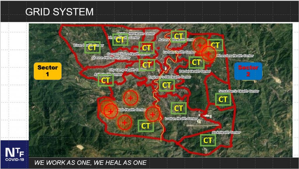
The City Government of Baguio developed the Baguio Contact Tracing Ecosystem to serve as the main platform for implementing its plans and strategies against COVID-19. The system harmonizes seventeen cluster areas headed by health professionals with about 20 to 40 members per cluster, using epidemiological analysis to study the spread of the virus across the population. The organizational framework also includes an auxiliary team composed of police officers, investigators, and medical technicians.

Background and Problem

Through the years, the Baguio LGU has dealt with numerous infectious diseases such as Severe Acute Respiratory Syndrome (SARS), meningococcemia, vaccine-preventable diseases, food and waterborne diseases, and dengue through the effort of the Health Services Office (HSO) City Epidemiology and Surveillance Unit (CESU). Learning from these past outbreaks, the CESU has emphasized contact tracing as an essential tool for public health. However, despite myriad reasons to establish a contract tracing system, such as the 2005 Meningococcemia outbreak which severely affected Baguio’s tourism industry and the fact that more than 70 Filipinos dying every day due to tuberculosis, the necessary technology has not been given much attention in the Philippines until the outbreak of COVID-19.

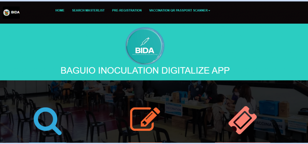
Screenshot of the Baguio Inoculation Digitize App

Solution and Impact

Given his experience as the Director of the Criminal Investigation and Detection Group from 2013 to 2015, Mayor Magalong, in April 2020, gathered the city’s epidemiologists, information technology experts, software engineers, computer programmers, and the police to discuss the development of a homegrown contact tracing mobile application. It took only two weeks of preparatory work to integrate health informatics with information technology, allowing the Baguio LGU to launch the app while simultaneously training the staff on using it.

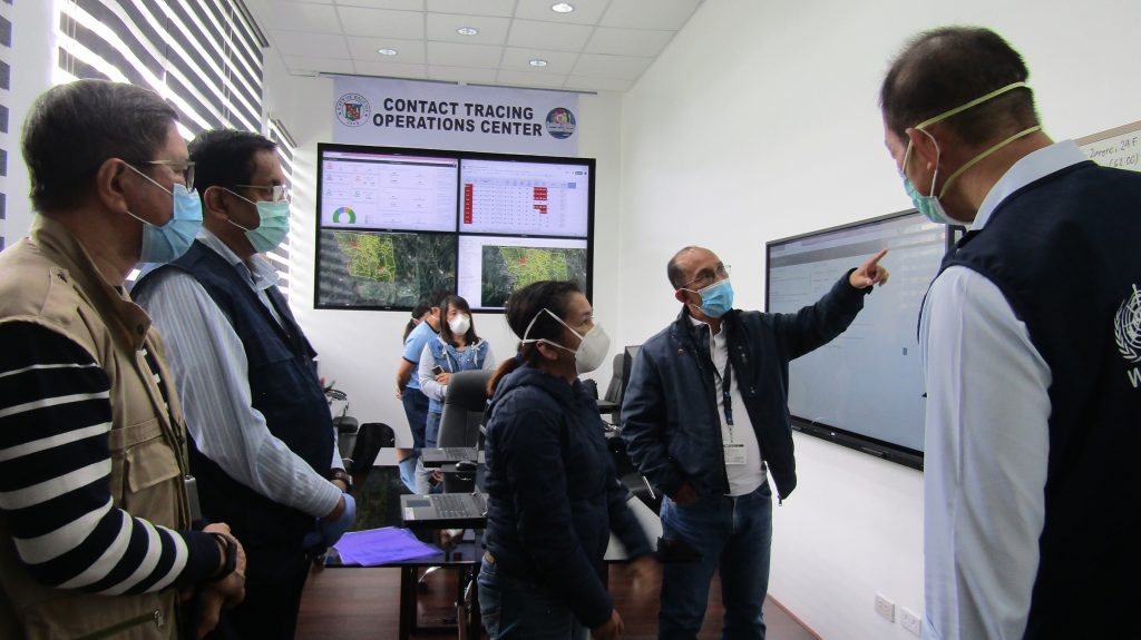
Baguio City Mayor Magalong presents the Baguio Contact Tracing Ecosystem to WHO Regional Director Kasai and DOH Undersecretary Dr. Gerardo Bayugo

The contract tracing system is composed of police, doctors, healthcare workers, barangay health emergency response teams (BHERTS), 5-10 swab teams, a lockdown team (composed of lawyers formulating the lockdown order), disinfection teams from the city government and barangays, encoders, analysts, programmers, and technical support. This setup allows other LGUs to easily replicate this system since the city only utilized its existing manpower and resources to implement it.

Baguio Contact Tracing Ecosystem

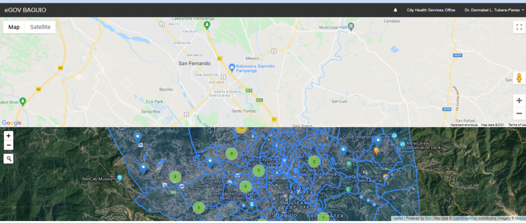
The Baguio Contact Tracing Ecosystem uses visualizations created by its communications team to make the numbers and information more understandable to the public. It also serves as an operational tool to collect and analyze COVID-19 case data as well as a geographic information system platform. The system can generate reports required by national government agencies such as the Department of the Interior and Local Government (DILG) and the Department of Health (DOH), using IBM Security i2 Analyst’s Notebook software which reveals relationships between a person and the virus across space and time using the ELP (entity-link-property) methodology. This allows the system to show the possible link between COVID-19 cases, from whom the virus originated, and who will be the next person to be infected, which the HSO acts on by instituting preventive and control measures to stop the spread of the virus. Lastly, CESU also uses a Geographic Information System (GIS) to geotag all COVID-19 cases in any area, leading to better decision-making for the city government to ease restrictions.

Screenshot of the eGov Baguio Geographic Information System

What sets the Baguio Contact Tracing Ecosystem apart from other contact tracing solutions is that it uses a patient-centered approach that emphasizes the continuity of care from diagnosis, treatment, recovery and even post-illness economic relief. Furthermore, the system is integrated within the LGU’s different offices and units, allowing for the coordination of different efforts in social welfare and public order and safety.

Baguio Contact Tracing GRID System

Because of this application, the Baguio LGU was also able to implement evidence-based decision-making to lessen the economic impact of the pandemic, as it was the first LGU to implement granular lockdowns. Residents of the city can confidently rely on a robust and transparent contact tracing system implemented by the LGU, which has also strengthened the value of being truthful, especially when declaring symptoms or the location of possible COVID-19 cases. Lastly, the system has granted the LGU and the city confidence that they could capably manage such large-scale disasters.

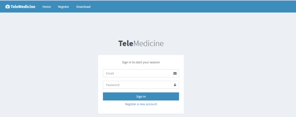
The system has also adapted to the shifting context of the pandemic, expanding its services from just contact tracing to scheduling and tracking vaccinations and telemedicine consultations. New features include the generation of paperless vaccination certificates for its citizens and a telemedicine platform.

Screenshot of the Baguio Telemedicine Website

Milestones

The system was first launched on 20 March 2020 and it can be accessed at http://endcov19.baguio.gov.ph.
On 10 July 2020, the World Health Organization led by WHO Western Pacific Regional Director Dr. Takeshi Kasai and WHO Philippine Representative Dr. Rabindra Abeyasinghe, and DOH Undersecretary Dr. Gerardo Bayugo honored the city and its provincial governments with a field visit to learn about their best practices in managing the COVID-19 pandemic.

The system won third place nationwide as the Best in COVID-19 response in the 2020 Digital Governance Awards organized by the Department of Information and Communications Technology (DICT), Department of the Interior and Local Government (DILG), and the National ICT Confederation of the Philippines (NICP) last 14 December 2020. It was also featured in sharing sessions for Myanmar in January 2021 and South Korea in October 2021.

Testimonials

“On a recent visit to Baguio, I was impressed to see first-hand the system that contact-tracing czar. And Baguio City Mayor, Hon Benjamin Magalong, and his team are implementing to #BeatCOVID19.”

Dr. Takeshi Kasai, Western Pacific Regional Director, World Health Organization, 26 July 2020.

“Baguio City is far ahead in their contact tracing because local officials are working together with health officials. This should be replicated in other LGUs in the Philippines,”

Dr. Rabindra Abeyasinghe, Philippine Representative, World Health Organization.

Sources

Cabreza, V. (2020, May 28). Philippines top stories: Politics, environment, education, trending. Inquirer.net. Retrieved April 8, 2022, from https://newsinfo.inquirer.net/

Department of Interior Local Government Cordillera Administrative Region. (n.d.). 2020 DG award: Baguio is Country’s third best in covid-19 response. Department of Interior Local Government Cordillera Administrative Region. Retrieved April 8, 2022, from https://car.dilg.gov.ph/field-office/dilg-baguio-city-home/19-dilg-baguio-city/88-2020-dg-award-baguio-is-country-s-third-best-in-covid-19-response

World Health Organization. (n.d.). WHO field visit to Baguio City and Benguet Province: Models for contact tracing and covid-19 response in the Philippines. World Health Organization. Retrieved April 8, 2022, from https://www.who.int/philippines/news/detail/29-07-2020-who-field-visit-to-baguio-city-and-benguet-province-models-for-contact-tracing-and-covid-19-response-in-the-philippines

Title

Corazon Locsin Montelibano Memorial Regional Hospital Anesthesia Care Nurse Program

Organization

Corazon Locsin Montelibano Memorial Regional Hospital

Best Practice Focus Area/s

Human Resource

Year Implemented

September 2, 2013

Summary

The Corazon Locsin Montelibano Memorial Regional Hospital (CLMMRH) Anesthesia Care Nursing Program (ACNP) was developed in 2013 to address workforce shortages and enhance service delivery by training nurses to become competent at perioperative anesthesia care. CLMMRH developed this program by integrating into its curriculum the training of nurses who can assist physician-anesthesiologists, especially in rural government hospitals. With anesthesiologists operating as frontliners during the COVID-19 pandemic, those trained by the ACNP program have also proven to be important contributors, as their specialized skills allow them to perform delicate procedures such as the intubation of patients who need ventilators.

Background and Problem

As the only government tertiary hospital on Negros Island, CLMMRH is the end-referral hospital for Bacolod City, Negros Occidental, and neighboring towns in both Regions VI and VII.[2] However, despite the increase in the number of beds in 1981 by virtue of Batasang Pambansa Bilang 118, there was no corresponding increase in personnel positions up to 2013.

The lack of corresponding increase in the hospital’s workforce for those 32 years resulted in a shortage of healthcare workers for the growing population. Bacolod City alone grew from a population of 364,180 to 511,820 from 1990 to 2010, and there was still no increase in bed capacity or personnel services. In 2008, Region VI only had 234 doctors and 401 nurses in government and 0.78 beds per 1,000 population.

The services of the Department of Anesthesiology suffered during 2013, as the doctor-to-patient ratio was one doctor to every 21,632 population in Bacolod City, and was 1 for every 47,527 in Negros Occidental. From 2011 to 2012, only five full-time consultants and six resident anesthesiologists manned six operating rooms and attended to 5,816 cases annually. This was when there were very few medical graduates due to the exit of nurses from the country. There were no applicants for residency training in the department for 2012 and 2013. The two-year gap resulted in only two residents remaining in the middle of 2013.

This workforce shortage burdened anesthesiologists-controlled processes in the operating room and resulted in long turnaround times, the cancellation of scheduled surgeries, and overall decreased capacity. Dr. Julius Drilon, the Medical Center Chief, challenged the department in 2013 to innovate and empower the nurses to address this problem, with the main goal of fulfilling the organization’s mandate to deliver accessible, safe, equitable, efficient, and affordable anesthesia care. The initiative also sought to train nurses in the necessary competencies to complement the physician anesthesiologists so that service can be delivered to every patient consistently.

Solution and Impact

The solution to the workforce shortage was to design and implement a program that will empower nurses and enable them to be effective and efficient members of the anesthesia care team.

The training program introduced medical knowledge essential to understanding concepts in anesthesiology through a series of didactic lectures and case methods. These were aimed at developing anesthesia-related clinical competence among the nurses, subject matter beyond the scope of the usual medical, surgical and intensive care nursing. Trainees were made to demonstrate skills in performing safety checks, drug preparations, and assisting in performing anesthetic techniques. Emphasis was also given to non-technical skills such as communication skills, use of technology, and practice of evidence-based medicine. Most importantly, the trainers integrated values of professionalism, integrity, and teamwork to cultivate a culture of safe, humane, and compassionate care among the trainees.

On September 2, 2013, the CLMMRH Nurse Anesthesia Assistant Training Program (NAATP) started with four nurses, but the program was soon renamed to ACNP following the issuance of Department of Health (DOH) Administrative Order No. 2014-0014.The CLMMRH ACNP retained several features of the NAATP, including earlier exposure to clinical cases for skills-learning and a hands-on approach during tutorial sessions with consultant and senior resident anesthesiologists, which has proven essential to developing clinical competence. The program immediately contributed to easing surgical backlogs in the first year of implementation, as it was found that while only 85.02% of cases scheduled in October 2013 were performed, the figure had reached 99% by November 2014.

On March 14, 2020, the department deployed its team to respond to the COVID-19 pandemic, which led to a paradigm shift in the role of anesthesiologists in emergency care. The CLMMRH COVID-19 Airway Team is composed of a consultant or senior resident anesthesiologist and an anesthesia care nurse who are capable of performing intubations for suspected, probable, and confirmed COVID-19 cases. This is unique to CLMMRH as there have been no reports of any other institution in the Philippines where anesthesia care nurses have successfully performed this role–the CLMMRH COVID-19 team has had no record of failed intubation or any breach in infection control procedures.

Milestones/Next Steps

Since September 2013, the program has had five batches–one as NAATP and four as ACNP–with a total of 17 nurses trained. In October 2014, DOH conducted a site visit to inspect the program’s learning activities, instructional design, and implementation of said learning activities, as well as to interview four of the program’s trainees. Overall, the DOH found ACNP to be satisfactory and advised modifications to adopt specific topics in didactic lectures. Subsequently, the training program duration for the second batch was extended by six months.

References

Drilon, J., Tagbilaran, J., & Marisol, R., Quality Management System manual QMS.QM.001 Issue No. 006 (2020). Bacolod City.

Local Water Utilities Administration. (n.d.). Philippine Population Census. Provincial Population Data. chart. Retrieved June 18, 2020, from http://122.54.214.222/population/index.htm.

Manyazewal, T. (2017). Using the World Health Organization health system building blocks through survey of healthcare professionals to determine the performance of public healthcare facilities. Archives of Public Health, 75(1), 1-8.

Office of the Secretary, A.O. No. 2014-0014: Guidelines on the Department of Health Anesthesia Care Nursing Program (2014). Metro Manila; Department of Health.

Philippine Statistics Authority, The 2015 Census of Population (POPCEN 2015) (2015). Quezon City.

Department of Health. (n.d.). The Philippine Health System at a Glance. Department of Health. Retrieved March 30, 2022, from https://doh.gov.ph/sites/default/files/basic-page/chapter-one.pdf

Center for Health Development Western Visayas, 2013 Field Health Service Information SystemAnnex 3B.1 (2014). Iloilo City; Department of Health Center for Health Development Western Visayas.

Title of Productivity and Innovation Initiative

Project iComSys (Integrated Community Information System)

Implementing Agency

Municipal Government of Libertad, Antique

Year Implemented

2019-Present

Themes

Digitization & New Technologies, and Government of the Future

General Description

Project iComSys or the Integrated Community Information System is a data management system locally created, operated, maintained, and utilized by the Libertad LGU. This has helped shape its development and make the people the center of its governance. Project iComSys utilizes a cloud-based system responsible for collecting, managing, and utilizing databases for the respective communities. It is also concerned with the maintenance of a data banking system.

Background and Problem

The Libertad LGU has always struggled with storing, accessing, and managing the community’s data and information. Due to the lack of a system, developing programs and projects to make it more targeted is challenging because they do not have the database to identify the population that urgently needs support and assistance.

In 2016, the new administration of Mayor Mary Jean Nicopior-Te had to run a local government with an inferior data management system. The LGU depended on the PSA data, which only comes every five years, and thus planning indicators were derived from years-old records. The development planner had no choice but to use unvalidated data, while barangays relied on poor municipal records. This situation meant that decision-makers were provided with incomplete and incorrect data, resulting in poor planning and budgeting, ineffective program implementation, and inefficient local governance.

Confronted with these realities, the incumbent local chief executive was determined to change the system and established a database system that is reliable, user-friendly, accessible, updated, and secure.

Solution and Impact

The Libertad LGU acknowledged the importance of Information and Communications Technology (ICT) and started to look for experts in the said field capable of developing a system. Due to its past difficulty, the municipality considered creating a system where they can store, manage, and quickly access the data of the community. These needs led to the introduction of Project iComSys in 2019.

The data collection process for Project iComSys includes enumeration, validation, encoding, and evaluation.

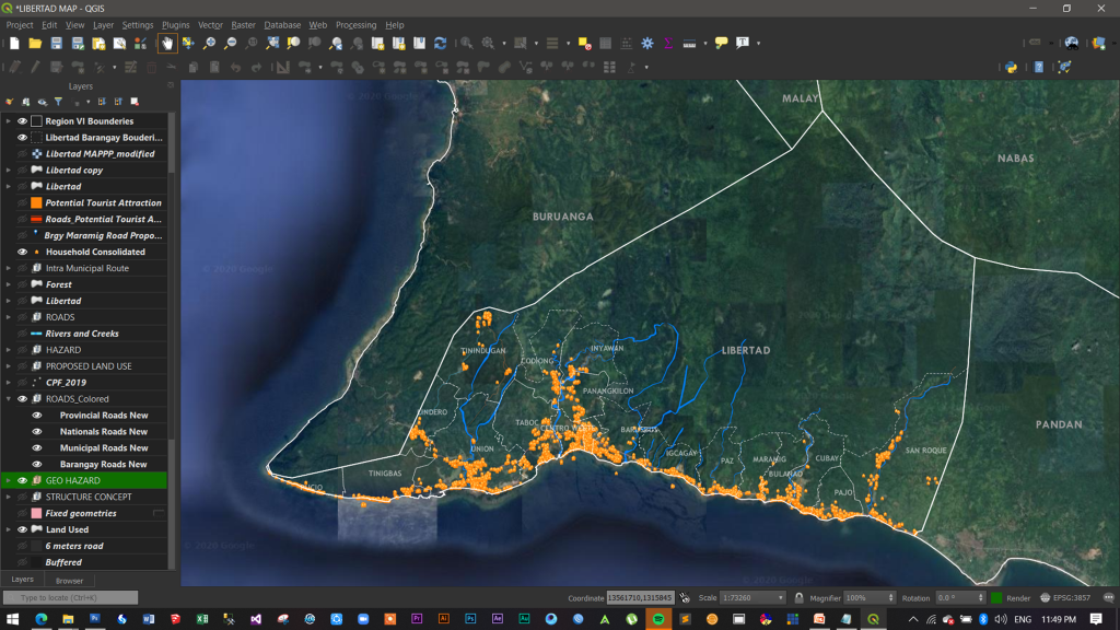
Project iComSys has since served as an efficient and effective tool for the municipality. It is used to gather and organize data on population, education, livelihood programs, and projects to make accurate analysis more accessible with just a simple click. Even the municipality’s map for planning and decision-making has become more accessible. Moreover, the system has motivated the municipality to continue delivering quality services to its constituents since they have a database system that serves as guidance to target the vulnerable population. The intervention was implemented from 2019 to the present. This was through a municipal executive order creating the team and implementing the Project iComSys.

Screenshot of the Geographical Information System

The population data generated by the project was also used to ensure the efficient and effective implementation of the Social Amelioration Program (SAP) of the Department of Social Welfare and Development (DSWD) during the COVID-19 community quarantine measures. Through Project IComSys, the LGU was able to identify the number of households per barangay, rank them according to economic status, prioritize eligible beneficiaries for SAP, post the data on the barangay and bulletin board for the people to see, and deliver the aid to the household beneficiaries. As not all households were qualified, the LGU provided one sack of rice and one tray of eggs to those who were not SAP beneficiaries.

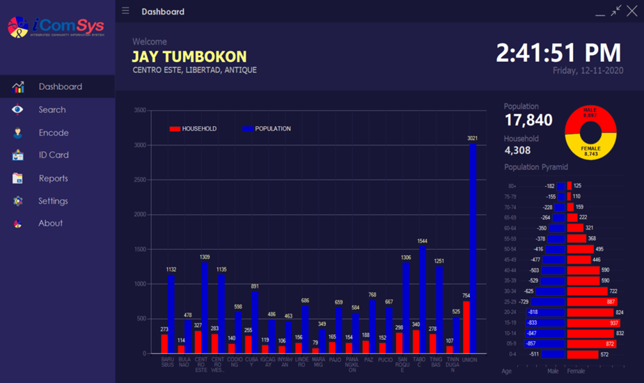
Screenshot of Project iComSys Dashboard

The data management system is also at the forefront of monitoring the accomplishment of the barangay vaccination rollout. The municipal health office can identify the number of vaccinated citizens by age and gender and also monitor how many have received the first, second, and booster doses. With better information and a clearer picture of the barangays, leaders and the municipal IATF can easily plan, identify specific issues and concerns, implement better solutions, and devise a well-targeted communication plan.

In the recent distribution of cash aid for typhoon Odette, it took less than ten days to finalize the list and distribute the cash to 100% of the households in the municipality. This is because of the utilization of the population data in Project iComSys.

Milestones

During the annual Digital Governance Awards 2020, the Municipality of Libertad, Antique, was recognized for Project iComSys, and declared the 2nd placer under the category Best in eGOV Interoperability (G2G) Award. The category commends the efforts of LGUs in establishing a system that connects the data with both national and local government offices to enhance public service delivery and the benefit of their constituents.

References

DICT. (2020, December 18). Excellence in local ICT solutions recognized at DGA 2020. GOVPH. https://dict.gov.ph/excellence-in-local-ict-solutions-recognized-at-dga-2020/

Mayor Bebot Nicopior-Te. (2020, November 09). Digital Governance Awards [Facebook status update]. Facebook. https://www.facebook.com/mayorbebotte/posts/digital-governance-awardsnag-intra-ang-aton-banwa-bilang-entry-sa-2020-digital-g/2511934025598264/

Mayor Bebot Nicopior-Te. (2020, December 20). Digital Governance Awards 2020 [Facebook status update]. Facebook. https://www.facebook.com/mayorbebotte/posts/2588746131250386?comment_id=2588797914578541

Title of Productivity and Innovation Initiative

Barangay Centralized Wireless Network

Implementing Agency

City Government of Cauayan, Isabela

Year Implemented

2015-Present

Themes

Management for Productivity, Quality, and Agility, Digitization & New Technologies, Perspectives on Productivity, Governance, and Development

General Description

The Barangay Centralized Wireless Network is a communication network that allows for file sharing, real-time notifications, and messaging between the 65 barangays of Cauayan City. This was intended to enable faster and more timely dissemination of data between the local government of Cauayan City and its barangays. The project also provided internet to the barangays, the local government’s main point of access to the internet.

Background and Problem

Before this program, the barangays and the local government met face-to-face to discuss the concerns, plans, and programs. This arrangement had been problematic at times, given the limited availability of concerned officials. There would be times when concerned officials would even have other equally important engagements, leading to postponed meetings.

Moreover, there was no other avenue for open discussion and interaction among the barangays themselves. Data, announcements, and other information had to be transmitted first to the local government and then to the barangays rather than being transmitted among the barangays themselves. Also, information was typically transmitted through paper documents requiring a messenger to distribute them to the barangays personally.

There was also no centralized server that contained documents and data of the barangays. An internet-based solution could have been made, but some barangays did not have a stable internet connection, with those in remote areas not having internet access at all.

Solution and Impact

On August 17, 2015, access to an LTE broadband internet connection was provided to all of Cauayan City’s barangays for free. However, since LTE broadband is location-dependent, some barangays in remote areas still did not have a strong and stable connection due to their lack of proximity to the site. The LGU addressed this issue in 2017 when they worked with PLDT to install a dedicated internet connection infrastructure using fiber optics. And to this date, all five regions of the city have been installed with the same internet infrastructure. These cumulative efforts upgraded internet connectivity overall and led to the creation of the Barangay Centralized Wireless Network.

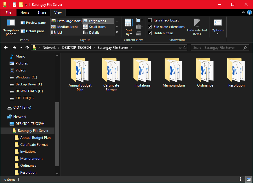
Barangay File Server located at LGU Cauayan City

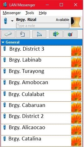
The Barangay Centralized Wireless Network allows the local government to send information and documents to the barangay level in real-time. It has a LAN Messenger that allows the barangays to collaborate with other barangays and even with the local government through a private communication channel and an Intranet File Server where the local government can host the files of barangays. This allows their files to be accessed anytime without personally going to the local government office.

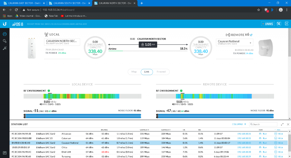
Sector Radio and Antenna Dashboard

The improved internet connectivity also allowed the barangays to utilize other e-media platforms and digital solutions which the local government had already developed. It also provided free internet access to the residents of the barangays via a guest WIFI network that is separate from the intranet. Their guest WIFI is also more stable because of the point-to-point sector antenna rather than a broadband connection.

Sample LAN Messenger and File Sharing

Also, with the local government managing the distribution of the internet, they can assure that internet connectivity is efficiently distributed. They are also able to cut costs because instead of paying 65 internet accounts for the barangays, the local government needs to pay only one account. It also removes the need for barangays to have individual internet postpaid plans, which over time, could save them a lot from their monthly billing.

Milestones

In 2019, Cauayan City was chosen as one of the six winning local government units in the Digital Governance Awards (DGA) because of their Barangay Centralized Wireless Network, which was awarded the “Best in eGOV Government Interoperability Empowerment” (Philippine News Agency, 2019).

And according to an interview in September 2021, Atty. Reina Santos, head of the City Information and Communications Technology Department and the designated Smarter City Officer of the local government of Cauayan, mentioned that because the network had been so warmly received and especially because of the circumstances surrounding the pandemic, the local government has been pushing for the barangays themselves to allocate greater portions of their budget to installing more internet infrastructure rather than waiting for the local government to provide them more infrastructure.

Testimonials

In the same interview, Atty. Santos also mentioned that despite Cauayan City being mostly agricultural, the network has increased demand for internet connectivity, with citizens requesting additional bandwidth.

Sources

Dela Cruz, R. C. (2019, November 29). 6 winning LGUs in Digital Governance Awards 2019 get China trip. Philippine News Agency. Retrieved October 20, 2021, from https://www.pna.gov.ph/articles/1087200.

Cauayan City Local Government. (2015, August 15). Official Launching of Cauayan City Free Wifi and Distribution of 2nd Batch Brgy. Patrol [Video]. Facebook. https://www.facebook.com/cityofcauayanofficial/videos/1017101824996476/

Cauayan City Local Government. (2015, August 19). TV Patrol – Cauayan City Free Wifi and Patrol Vehicle News. [Video]. Facebook. https://www.facebook.com/cityofcauayanofficial/videos/1018079748232017/

Title of Productivity and Innovation Initiative

Guagua Geographic Information System (GGIS)

Implementing Agency

Municipal Government of Guagua, Pampanga

Year Implemented

1997-Present

Themes

Management for Productivity, Quality and Agility, Digitization & New Technologies, and Perspectives on Productivity, Governance, and Development

General Description

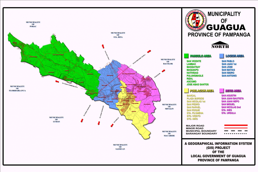
The Municipal Government of Guagua is one of the first LGUs in Region III that started the development of a Geographic Information System (GIS.) Through the assistance of the Australian Agency for International Development (AusAID) and the Philippine Land Information System, the Guagua Geographic Information System (GGIS) project was first launched in 1997. The GGIS spatial maps and database is widely used in Comprehensive Land Use Planning (CLUP), local disaster risk management, traffic management, and the administration of tax programs such as land valuation and land use. At present, it is continuously being updated by the Office of the Municipal Planning & Development Coordinator (MPDC).

Background and Problem

The geographic location of the Philippines makes it a disaster-prone country, as it regularly faces natural hazards such as typhoons, flash floods, landslides, earthquakes, and volcanic eruptions. This state of affairs is expected to intensify in severity and impact in the coming years due to climate change, continually hampering the economic development of the country and causing widespread destruction of resources and property. The 1991 eruption of Mount Pinatubo in particular has taken a serious toll on the people of central Luzon, displacing more than 10,000 families and dramatically altering the landscape of the area, thus necessitating an updated mapping system for preventive planning and action.

The Municipal Government of Guagua, Pampanga, is located along the Pasig Potrero River Control System (PPRCS), one of Mount Pinatubo’s main river channels, thus making the residents vulnerable to any further volcanic activity. Apart from this, land tax management, such as determining the exact figure area, is also one of the challenges since the municipality has over 10,000 parcels in just 4,875 hectares.

Solution and Impact

At present, the most frequent use for GGIS is to provide land developers and property owners with land use information, as these form the basis for property rights. The usual requested information varies in terms of property location, dimension, existing owners’ name, property rights, previous owners, missing and erroneous lots, values, and many other categories of spatial data. This removes the need to do research at the Land Management Services (LMS) since most data are available in the municipal office.

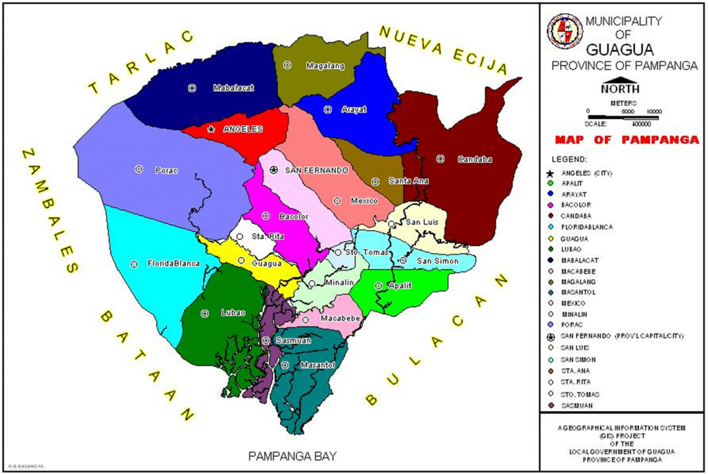
2021 GIS Map of Guagua

The GGIS can also be used to provide efficient and accurate tools for collecting, storing, retrieving, reporting, and displaying public information. The passage of a Sangguniang Bayan Ordinance through the local revenue code to collect minimum fees has helped augment the research activities of the MPDC Office.

For disaster response, thematic GIS mapping serves as an important tool to identify flooded barangays, risk areas, affected utilities, road accessibility, and possible lifelines and exit routes. In regular disaster preparedness activities, data are likewise presented in GIS format, making the discussions and planning more accurate and visually understandable.
To address resource and land use issues, GGIS is utilized to identify and analyze the development of the town’s land resources, support the preparation of land use plans for environmental regulatory programs, determining the best location for the proposed environmental projects such as landfills and material recovery facilities, identifying lots for reclassification purposes, capturing lot data for tax assessment and identification, maintaining property records, zoning, traffic management and rerouting, and tracking down encroachments, particularly along river channels.

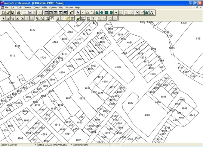
The applications of GGIS for Guagua have also expanded to include land registration and cadastre, transportation, risk management, resource, and land use issues in the local government functions. The area of land registration and cadastre is one of the most interesting areas in the use of GGIS and Land Information System.

2021 Parcellary Map of Guagua

Milestones

Out of a total of 108 LGU-initiated programs that participated in the 2020 Digital Governance Awards, the Department of the Interior and Local Government recognized 15 LGUs for making significant changes to improve their public service delivery amid the COVID-19 pandemic. The Municipality of Guagua, Pampanga was the champion under the category Best in LGU Empowerment (G2G) for GGIS.

To date, the GIS unit is housed in the MPDC office. Although the GIS project is not a priority of the administration, data collection and encoding are continuously undertaken despite the limited funds. The office has coordinated with the Lands Management Bureau RO3 to acquire photocopies of new subdivision lot plans and with the Registry of Deeds RO3 to provide copies of all new approved titles. Although it is not equipped with a plotter, the office could produce 1:4,000- and 1:2,000-scale maps of the town by printing them in regular bond papers then cutting and connecting all the portions. These scaled, hardcopy maps are used to identify missing lot data, overlapping lots, and barangay boundaries with much or reasonable accuracy.

2021 CLUP Map of Guagua

At present, 98 percent of all lot data, subdivision lot plans, and mother titles have already been encoded. With almost completed spatial data, the identification of barangay boundaries is being undertaken, based on existing cadastral lot boundaries, mapping boundaries, and Transfer Certificates of Titles. Since these three show different barangay boundaries, the concerned barangay councils are encouraged to negotiate amiably on the issue of barangay boundaries.

References

Bautista, C.B. (1999, October 06). The Mount Pinatubo Disaster and the People of Central Luzon. USGS Publications Warehouse. https://pubs.usgs.gov/pinatubo/cbautist/

Chavez, C. (2020, December 15). DILG Commends 15 LGUs for their digital governance solutions. ManilaBulletin. https://mb.com.ph/2020/12/15/dilg-commends-15-lgus-for-their-digital-governance-solutions/

Municipality of Guagua. (2010). Guagua Geographic Information System (GGIS) 2010. https://fdocuments.in/reader/full/guagua-clup

Vincenzo Bolletino et al., (2018). Perceptions of Disaster Resilience and Preparedness in the Philippines. Harvard Humanitarian Initiative. https://hhi.harvard.edu/publications/perceptions-disaster-resilience-and-preparedntess-p

Title of Productivity and Innovation Initiative

Electronic Moncada App

Implementing Agency

Municipal Government of Moncada, Tarlac

Year Implemented

2021-present

Themes

Digitization & New Technologies, and Government of the Future

General Description

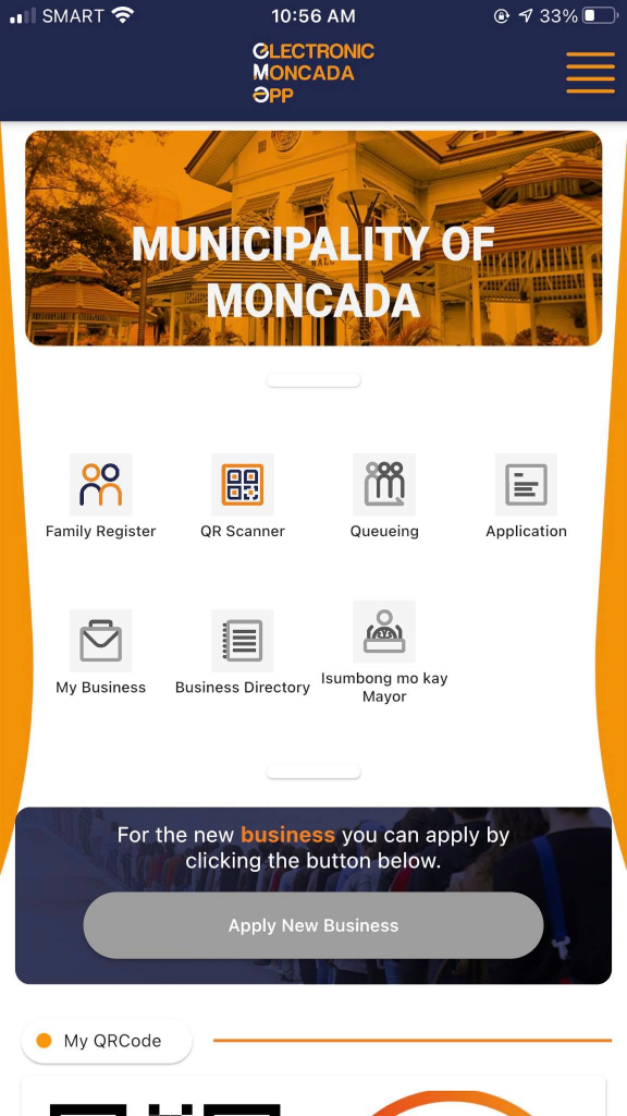
The Electronic Moncada (eMoncada) App is an all-in-one mobile application launched by the Municipal Government of Moncada, Tarlac, to lessen the necessity of face-to-face government transactions and control the spread of COVID-19 among the residents. It aims to centralize municipal services such as citizen registration and identification (Family Register), remote queueing, complaint filing (“Isumbong mo kay Mayor”), and the application, processing, and release of business permits. The app also contains other features such as QR codes for contact tracing, a business directory, and a log for the vaccination status and preferences of the residents.

Background and Problems

The eMoncada mobile application was initially conceptualized to primarily speed up data collection and facilitate the sorting of the general census for the Social Amelioration Program (SAP) distribution among residents. According to the 2020 Census (PhilAtlas, n.d.), the municipality’s total population is approximately 62,819, which makes records tracking and the SAP rollout relatively difficult if done manually. In addition, having one-stop-shop applications like this is one measure to curb the health risks involved in going to the municipal hall and enduring long lines for essential government transactions. Through the assistance of ezGov, a software and system integration company specializing in application and system development for various local governments in the country, the features were eventually expanded to cater to other municipal transactions.

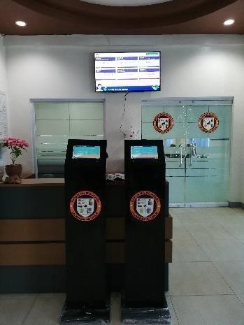
Moncada LGU Kiosk

Solution and Impact

The eMoncada App is a proactive solution of the Moncada LGU to control the spread of the COVID-19 virus in the municipality. Through the application, municipal transactions and services became more efficient. One of its most important features is the Family Register, which served as the LGU’s means to systematically gather general census information for the SAP distribution in the municipality. This enabled them to prioritize infected residents, those who belong to lower-income households, and senior citizens. Another feature available on the app is vaccine information, where residents who have not yet been vaccinated may access a survey regarding their preferred COVID-19 brand and indicate their existing health conditions. It also allows users to apply for vaccination and generate their vaccine records that may serve as their proof of vaccination.

Electronic Moncada App Home Screen

The app also consists of a contact tracing feature that enables its end-users to register their basic information in the LGU’s database for easy tracking in case of potential exposure to confirmed COVID-19 cases. With the mayor’s issuance of Executive Order No. 08 Series of 2021, commercial establishments in the municipality were issued with QR codes and urged to use the eMoncada App for electronic business transactions and contact tracing efforts.

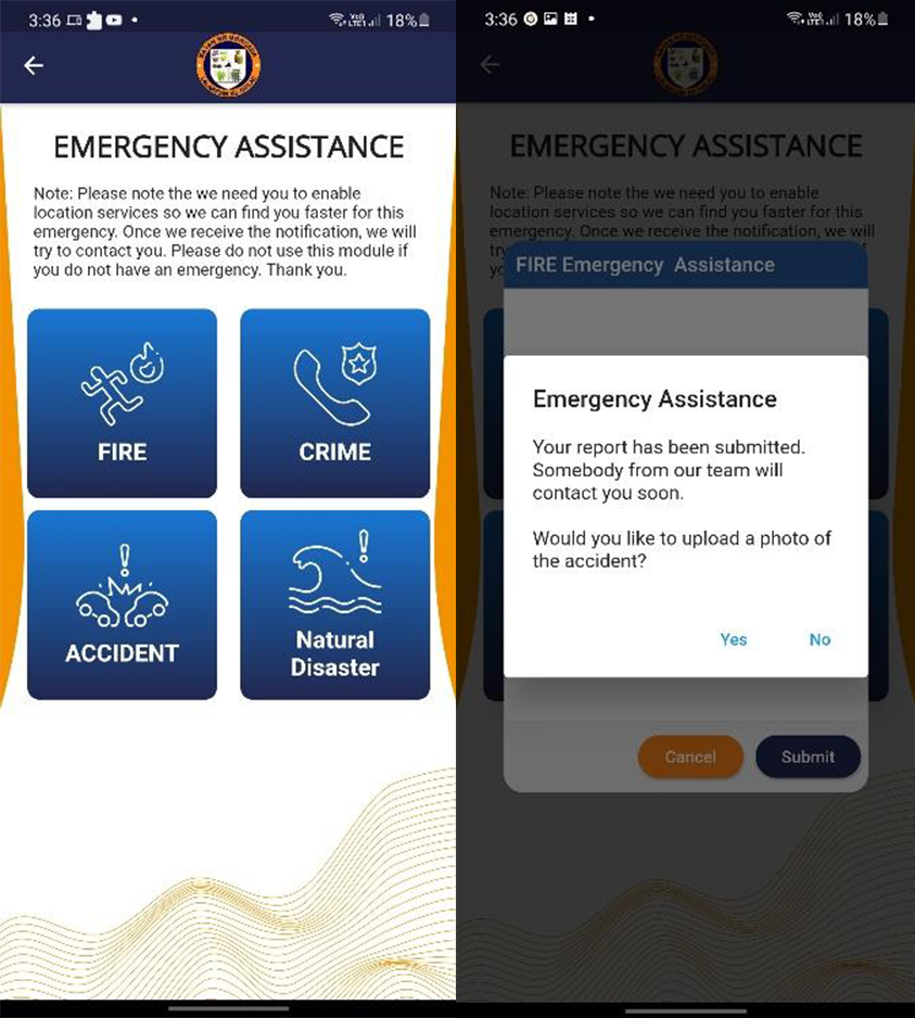
The application also has an emergency assistance button that enables residents to report accidents and other emergencies and send photos. It also allows for the tracking of the sender’s location through GPS. Once the report is submitted, a designated team member will contact the sender, verify the report, and respond immediately.

Another feature is the BPLO Online Application integrated into the current eBPLO system onsite, allowing residents to remotely apply for a new business. The LGU targets to expand it in the future to also have payment integration with Paymaya.

Finally, the app also offers remote queueing, allowing residents to set appointments online. This enables the LGU to control the number of daily transactions and maintain the efficiency of its processes.

Emergency Assistance Feature

To address their constituents’ apprehensions about embracing government efforts to digitalize, the Moncada Municipal Information Office has continuously conducted media campaigns and information drives on the features and advantages of the app through social media. The LGU also set up a kiosk in the municipal hall lobby to assist residents in registering to the app and encoding the details of their transactions with the assistance of LGU personnel.

Milestones

The eMoncada App won second place in the municipal-level Best in Government COVID-19 Pandemic Response Award (G2P) during the Digital Governance Awards (DGA) 2021 last 29 October 2021. Formerly known as Digital Cities PH Awards, DGA is spearheaded by the Department of Information and Communications Technology (DICT), the Department of the Interior and Local Government (DILG), and the National ICT Confederation of the Philippines (NICP).

Sources

Newsbytes.PH. (2021, November 3). 40 LGU systems win Digital Governance Awards. Newsbytes.PH. Retrieved from https://newsbytes.ph/2021/11/03/40-lgu-systems-win-digital-governance-awards/?fbclid=IwAR3ymAnxJpPUksclFHX4ezbY9kzY5gHLiTuhbPNppYDgPLHDnb0UWZlo0RI

Moncada Information Office. (2021, November 11). Nandito na ang E-Maligayang Pasko sa Moncada. Retrieved from https://www.facebook.com/MoncadaPIO/posts/4512628135493549

Moncada Information Office. (2021, February 24). Executive order urging commercial establishments and offices to use the e-Moncada Mobile Application for electronic business transactions and contact tracing efforts to prevent the spread of COVID-19 in the municipality. Retrieved from https://www.facebook.com/MoncadaPIO/photos/a.1938336526256069/3746299202126450/
PhilAtlas. (n.d.). Moncada, province of Tarlac. Retrieved from https://www.philatlas.com/luzon/r03/tarlac/moncada.html

Title of Productivity and Innovation Initiative

Geohazard Mapping Information System

Implementing Agency

City Government of Cebu

Year Implemented

2000-Present

Themes

Technology, Disaster Risk Reduction and Management

General Description

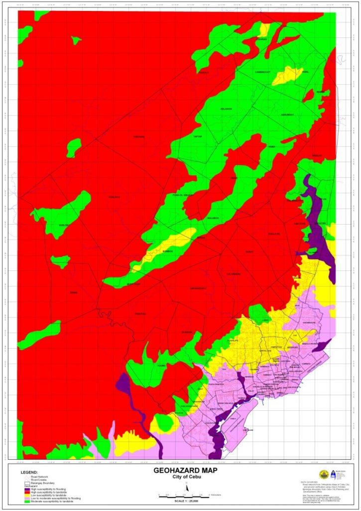
Cebu City experiences a substantial number of geohazards. Also, prior to any intervention, their disaster management had mostly been focused on response and has been quite lacking in mitigation or preparation. Because of this, the LGU expanded its Geographic Information System (GIS) to create the Geohazard Mapping Information System (GMIS). Initially, the GIS had limited features that could only be used for land use planning, subdivision review, and tax mapping, but the functionality of the GMIS has been expanded to include preparing and responding to disasters at all levels. Particularly, the GMIS excels in providing information regarding key geohazard concerns and it has since aided them in implementing disaster resilient projects, especially those concerning infrastructure.

Background and Problems

Cebu City has its fair share of both natural and man-made geohazards, such as storms, floods, landslides, tornadoes, earthquakes, fires, and even epidemics. However, before the Cebu City LGU’s Local Disaster Risk Reduction Management Office (LDRRMO) had the GMIS, much of their efforts had only been concentrated on response, reconstruction, and restoration. Because their maps before the GMIS did not yet contain the necessary information, they had not been able to fulfill their responsibilities in disaster mitigation.

A notable example of this deficiency in mitigating disasters was evident in their handling of the city’s informal settlers, who used to build illegal structures along rivers, creeks, and sidewalks. These structures have cumulatively reduced the capacity of these waterways, making them narrower and shallower. Because of this, the flow of floodwater would recede slower even in low rainfall, thus causing floods around the area of SM City Cebu and some of the barangays in the city proper. It would often be the case that the same informal settlers were also the first to be affected by these floods.

Although the Cebu City LGU did implement an ordinance requiring three meter easement along waterways to mitigate this issue, they still had to spend a substantial amount of time finding temporary evacuation centers and relocation sites for the informal settlers. Particularly, LDRRMO staff had to manually go to sites and negotiate with barangay officials or private owners about placing evacuation centers and relocation sites in their premises.

Solution and Impact

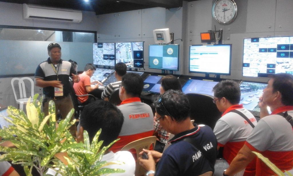
In 2000, the Cebu City LGU’s GIS staff and LDRRMO staff formed a team to conduct comprehensive field surveys using GPS equipment. The survey data was overlaid on existing maps in their GIS and complemented with historical disaster data to create the initial GMIS. In line with geohazard monitoring, the local government also installed 35 CCTV cameras at strategic places and intersections of the city. And shortly after implementation, even barangay officials had also been involved in conducting field surveys to keep the geo-hazard maps updated.

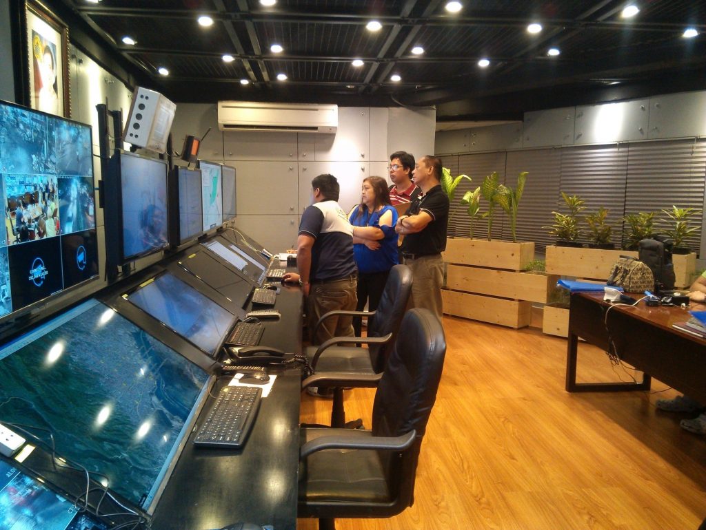
Cebu City Command Control Center (C3)

The GMIS has since acted as a source of readily available information for key geohazard concerns like:

  • Heavily populated communities
  • Coastal areas that are not easily accessible
  • Old roads, bridges, creeks, drainages, and buildings
  • Bodies of water that could be potential mosquito habitats
  • Areas that could be affected by sea-level rise and storm activity
  • Shapes and contours of lands for understanding the flow of water
  • Areas prone to fire
  • And many more

These kinds of data have been useful for their disaster response, reconstruction, restoration, and even mitigation—something they had been lacking in initially. This emphasis on disaster mitigation has allowed the GMIS to make some notable contributions to the city’s strategic development, particularly around the development of infrastructure and city planning.

Cebu City Geohazard Map

For example, In 2013, the planning for the Cebu City LGU’s Bus Rapid Transportation (BRT) project was conducted with the aid of the GMIS. Through the GMIS’s aerial photos, an efficient and disaster resilient bus route was identified.

And in 2014, the GMIS aided in the implementation of the LGU’s Reblocking Project. The reblocking aimed to provide wider roads for fire trucks, rescue vehicles, and police forces to have easier access to interior residential and commercial areas. The project cost PHP 35,000,000 and consisted of road widening, drainage construction, inspection of electrical connections, and the relocation of affected families. In this project, the GMIS was able to identify seven key high-population barangays for the project. It was also able to contribute to the efficient allocation of resources by providing information on areas that were most prone to flooding. This had led the project team to identify the necessary roads to widen easily.

The tool has also aided the LGU in many other ways. For instance, it contributes to the crafting of the city’s annual Disaster Management Plan. Notably, it is 5% of the city’s total annual budget. And given the budget’s size, the GMIS has never been more important to ensure proper planning of resources. Also, it has been useful for conducting disaster awareness and preparedness education campaigns in all 80 barangays of the city. Through the tool, each barangay can be provided with maps showing disaster-prone areas within their barangay.

Cebu City Command Control Center (C3)

Also, the GMIS has benefited not only the city at large, but also the people who work towards the betterment of the city. Notably, before the GMIS, the time it took for Cebu City’s Department of Engineering and Public Works (DEPW) field engineers to estimate the lineal meters of culverts was two to three days. Now using coordinates from the GMIS, it now only takes 20-30 minutes.

Milestones

In 2018, Cebu City was chosen as one of the six winning local government units in the Digital Cities Philippines (DCP) Awards Night because of their Geohazard Mapping Information System. This project was awarded the title “Best Data-Driven Governance (D2G)” (SunStar Cebu, 2018).

According to an interview in October 2021 with Engr. Conrado Ordesta III, assistant department head of the Management Information Computer Services Department under the Cebu City LGU, the GMIS has also been useful beyond just geohazards, as it has also been useful in tackling the COVID-19 pandemic. Through the tool, Cebu City LGU’s could also monitor and visually plot the pandemic and the status of vaccinations throughout their city. Notably, they identified key areas that had low vaccination rates and thus were able to implement more targeted interventions, house-to-house vaccinations. He mentioned that this was even able to bring their vaccination rates above 50%.

Testimonials

In the same interview, Engr. Conrado Ordesta III mentioned that many of its users are happy with the project. Notably, he mentioned that their Fire Department has extended much gratitude to them as they can now respond more quickly, they now know where to station themselves more effectively, and they also now have a reference for where “wet” and “dry” fire hydrants are.

He has also observed that their rescuers are now more able to take proactive preparations for disasters, especially for landslides. He mentioned that a limitation they had before was their Disaster Office being in their city proper, yet many of their mountain-based barangays are the ones experiencing landslides. But through their GMIS, they had been able to put up satellite offices and evacuation areas at strategic locations.

Sources

Cacho, K. O. (2018, October 17). Cebu LGUs win big in digital cities ph. SunStar Cebu. Retrieved November 5, 2021, from https://www.sunstar.com.ph/article/1769659/Cebu/Business/Cebu-LGUs-win-big-in-Digital-cities-PH.

Title of Productivity and Innovation Initiative

Cagayan de Oro Electronic Budget System

Implementing Agency

City Government of Cagayan de Oro

Year Implemented

2016-Present

Themes

Management for Productivity, Quality and Agility, and Digitization & New Technologies

General Description

The Electronic Budget System (e-Budget System) is an automation tool used by duly authorized LGU personnel to manage the financial resources of the City Government of Cagayan de Oro. It is an online web-based application that can be accessed anytime and anywhere. The system collects and organizes financial information from a central database and integrates budget and payments management with accounting, fiscal reporting, receipt, and cash management under the city’s accounting and finance departments.

Background and Problem

Before the e-Budget System, the Cagayan de Oro LGU used an obligations and expenditures system, which could not generate the reportorial requirements of the City Budget Office. Consolidating financial reports was time-consuming, and the assigned staff had to render overtime work to meet deadlines. Requests for obligation were encoded, and offices should verify their remaining budget before payment processing. Also, obligation requests were monitored manually using log books which caused delays and errors.

Furthermore, manual recording of obligation requests was prone to misreporting and wrong posting. Moreover, data reconciliation usually takes time since hard copies are physically retrieved. After an audit, the remaining obligated amount is not automatically reflected in the concerned office’s budget. Approved disbursement vouchers for cheque issuance were manually recorded by writing on the ledgers, which can be prone to double reporting and deficiencies. Because of this, no real-time summary of issued cheques can be generated. Office liaisons from the LGU’s other departments should also personally visit the financial offices to follow up on requests, which was cumbersome and time-consuming.

Screenshot of the Cagayan de Oro e-Budget System

Solution and Impact

The Budget Office initiated the e-Budget System through the support of the Management Information System Office. It provides a sustainable resource planning solution that is flexible, adaptable, and extensible. The first functional and operational release came out in July 2017, with the main processor of the Budget Office in charge of managing the data and establishing the protocols for accountability. It provides a sustainable resource planning solution that is flexible, adaptable, and extensible. Automating financial controls makes it easier to process transactions, manage records, and generate reports since data is kept in just one system. This results in properly monitoring expenditures from an obligation request to cheque issuance.

The system also serves as an end-to-end budget management tool for the preparation, proposal, authorization, appropriation, execution, request, release, and payment. Currently, budget proposals are centrally encoded by the Budget Office. However, they can be delegated to proponent offices for easier budget consolidation in the future. The Annual Investment Plan is also planned to be included in the next system development.

When it was first implemented, the system was met with resistance since some employees were not familiar with using the application or had not experienced using a computer before. This was addressed by the conduct of training and feedback sessions. The user’s needs were prioritized and eventually included in improving the system, making it far more efficient than the previous workflow.

Milestones

The e-Budget System was started in October 2016. The initial budget management module came out one year later, which can perform budget allocation, financial plan, release, and obligation requests. At that time, the obligation requests are created by the Budget Office. As a result, the Statement of Appropriations, Allotment, Obligations, and Balances (SAAOB) report can be generated within minutes.

To further devolve the process, all offices with budget allocations were given access to the system in January 2018. These offices can now view their budget balance online and prepare and print their obligation request form. The Budget Office will just have to validate the submitted obligation entries. In March of the same year, the Accounting Office was given access to perform the fund control function to revert the remaining balances to the concerned office’s budget in real-time. Another feature was added in October that enables tax deduction and reporting to applicable transactions and suppliers. Finally, in December of that year, the e-Budget System was integrated with the Treasury Management System, which displays the audited amount and makes it available for cheque preparation and quickly retrieves the cheque transaction list.

A new module was introduced in February 2019 to record employee cash advances. It automatically alerts concerned employees through SMS and email to liquidate their outstanding advances immediately. In July, the General Services Office was granted access to the system to generate disbursement vouchers to purchase or pay for capital assets, infrastructure, and diverse supplies for office, medical, and utility use.

Because of its expanded features, the CDO e-Budget System was awarded 2nd Best in the e-Gov Inter-Operability Empowerment Category of the 2019 Digital Governance Awards held on 26 November 2019 at the Philippine International Convention Center, which was organized by the Department of Information and Communications Technology (DICT), Department of the Interior and Local Government (DILG) and the National ICT Confederation of the Philippines.

In July 2020, all LGU offices and national government agencies with an allocated budget by the City Government were provided access to the budget preparation feature. Proponents can now encode their office’s budget proposals, making data consolidation much easier.

The e-Budget System will continue to improve in the future with additional features through the support of its development team and other offices. By 2025, their target is to establish a Comprehensive Financial Management System that can be used by the local government and its 80 component barangays.

Testimonials

“I am confident enough about the budget data because of the efficiency the system ensures.”

– Guiney Molawan, Administrative Aide II, City Finance Department, City Government of Cagayan de Oro.

“We get to monitor the status of our Obligation Request in real-time. Also, system assistance is provided promptly.”

– Junefay Sinomio, Administrative Officer IV, Human Resource Management Office, City Government of Cagayan de Oro.

“Monitoring our accounts is much easier. This improves our office’s strategic plans in ensuring that all our services are being delivered to our clients. Also, we can track the status of our obligation requests. The E-budget System was indeed a very helpful tool in our financial management. The automation made our job easier.”

– Clarita Tonido, Day Care Worker II, City Social Welfare and Development Office, City Government of Cagayan de Oro.

“e-Budget System makes everything easy. We can easily monitor the budget of different departments.”

– Ana Rowena Cagadas, Administrative Officer IV, City Budget Office, City Government of Cagayan de Oro.

Sources

Department of Information and Communications Technology. (2019, November 28). DICT, DILG, NICP award LGUs’ outstanding digital initiatives. Retrieved from: https://dict.gov.ph/dict-dilg-nicp-award-lgus-outstanding-digital-initiatives/

Orias, P.J. (2019, November 27). City Government bags two digital awards. SunStar. https://www.sunstar.com.ph/article/1833889/cagayan-de-oro/local-news/cagayan-de-oro-city-government-bags-2-digital-awards

iFM Cagayan de Oro. (2020, April 28). Breakdown sa nagasto sa CDO City Government kabahin sa COVID-19 measures. [Link with thumbnail attached] [Status update]. Facebook. https://www.facebook.com/99.1iFMCDO/posts/basi-ni-city-budget-officer-atty-percy-salazar-ao-kini-ang-breakdown-sa-nagasto-/3430151983733384/

Implementing Agency

Municipal Government of Magallanes, Cavite

Year Implemented

2011-Present

General Description

The Community-Based Monitoring System (CBMS) is a systematic way of acquiring, processing, and verifying necessary data which will be utilized in program preparation and implementation to address the challenges in poverty. Republic Act No. 11315 mandated that the technology-based system be introduced and launched in every city and municipality, serving as an instrument for alleviating poverty and sustaining the community’s needs. 

CBMS is also being used to address different challenges brought by the COVID-19 pandemic. Disaggregated socio-economic data generated from/through CBMS has proven valuable in identifying/targeting beneficiaries for disaster risk preparedness and response interventions. Despite the signing of the Community-Based Monitoring System Act last 17 April 2019, not all LGUs were able to establish their own CBMS, with some unable to complete their modules. Given their early adoption of CBMS in 2011, the Magallanes LGU has an advantage over other cities and municipalities in implementing modules that further improve data collection and management.

Background and Problem

With the need to have a standard, accurate, comprehensive, and consolidated system to efficiently provide services to its constituency, the fourth class municipality of Magallanes, Cavite, adopted CBMS in 2011, eight years prior to its being required by law beginning in 2019. CBMS is an organized, technology-based system of collecting, processing, and validating data that may be used for planning, program implementation, budgeting, vulnerability risk mapping, and impact monitoring. 

While the Philippine Statistics Authority has reported a significant decrease in poverty incidence, the past five years have seen a downward trend in the poverty incidence rate, from 25.2 percent in 2012 to 23.3 percent in 2015 to 16.6 percent in 2018. But when the COVID-19 pandemic arose, it worsened the poverty condition in the Philippines beginning in 2020. Poverty, hunger, and out-of-school youth are some of the country’s common problems, with a significant number of Filipinos unable to sustain their everyday basic needs. Lack of necessary data makes it difficult for LGUs to assist the vulnerable and respond to this pandemic. 

Managing the COVID-19 pandemic requires data to target eligible beneficiaries in times of disaster. A lack of data makes it difficult for a municipality to determine the causes of poverty, formulate appropriate policies and programs, and effectively and efficiently implement the programs of the government.

Solution and Impact

To address the challenges brought by the COVID-19 pandemic, the Magallanes LGU utilized the CBMS to target beneficiaries who urgently needed support and assistance. The planning group of the Disaster Risk Reduction and Management Incident Management Team (DRRM-IMT) used CBMS data tools to identify the eligible target beneficiaries, thus reducing the processing time of consolidating all the required information. Pertinent and useful data on beneficiaries was easily generated since the CBMS Technical Working Group (TWG) is also part of the DRRM-IMT. The CBMS has made it easier and faster for the Magallanes LGU to develop programs and effectively allocate resources during the pandemic. The successful implementation of the CBMS has led to the following results:

  • 2,984 Social Amelioration Program (SAP) beneficiaries
  • 650 SAClolo SACakulangan (SAC) Program beneficiaries 
  • 2,199 senior citizens received medicines and vitamins
  • 315 persons with disabilities received food packs
  • 242 pregnant women and 300 lactating women received financial assistance worth PHP 1,000
  • 44 tricycle drivers received financial aid worth PHP 4,000
  • 6,079 households received relief goods and seedlings
  • 365 distressed overseas Filipino workers (OFWs) received financial assistance from the Overseas Workers Welfare Administration (OWWA) worth PHP 10,000
  • 153 frontliners received hazard pay
  • Identified 7 OFWs and 25 LSIs for isolation
Screenshot of the Community-Based Monitoring System of Magallanes

Milestones

The municipality of Magallanes commenced the first implementation of CBMS in November 2011. A five-member technical working group did the data processing and mapping in the Municipal Planning and Development Office. Data collection was paper-based, and encoding had to be done individually. 

In 2013, Mayor Edwin V. Sisante and Municipal Planning and Development Coordinator Roilan R. Reyes were invited to present at the 9th CBMS National Conference the actual applications of CBMS for disaster risk reduction management and climate change adaptation in the municipality.

The second round of CBMS was implemented in 2016, using a tablet-based data collection scheme called the CBMS Scan and Portal, which is more cost-effective than paper-based data collection. It used QGIS for mapping purposes and Statsim Pro to generate tabulated data. This technology also uses GPS for the location of households, unlike in the first implementation of CBMS, where all households were digitized manually using Natural Resources Database (NRD) Pro. All data collected are kept, owned, and managed by one member of the technical staff in the municipality. All information about the respondent is confidential. The local government complies with the Data Privacy Law and ensures the security and protection of any data obtained, used, and stored. Data Validation at the barangay level was done to inform the locals of the survey result, verify the accuracy of the data, and identify the significant problems in the area. 

In 2018, Mayor Jasmin Angelli Maligaya-Bautista was invited to present how the Magallanes LGU met the challenges posed by disaster preparedness at the 14th CBMS National Conference. The following year, a third round of CBMS was implemented that continued the use of tablet-based data collection.

Local government employees of Magallanes during the COVID-19 pandemic.

In 2020, the Magallanes LGU won 2nd place in the Best in COVID-19 Pandemic Response at the Municipal Level category of the Digital Governance Awards. In September of the same year, the CBMS TWG accomplished the Barangay Validation for every barangays and prepared the Barangay Development Plan.

The CBMS has made some significant changes and developments since the local government of Magallanes first utilized it. LGU Magallanes was known as one of the best implementers in the whole Province of Cavite. Data has a significant role in planning so the Magallanes LGU formulated plans ahead of time because data is already available. CBMS data was used in different plans and programs of the municipality.
Testimonials

“Base po dun sa CBMS data, madali po namin na-locate yung mga taong ito. Madali naming nalaman kung saan sila pupuntahan. Wala pang isang oras inabot yung aming relief operation sa aming barangay.”

Mar Reduca, Barangay Captain, Barangay Urdaneta, Magallanes

“Sa panahon ng COVID-19, napakahalaga po ng tulong ng CBMS dahil ito po ang ginamit ng LGU upang matukoy ang mga individual, sambahayan o anumang sektor para sa pagbibigay ng tulong base sa kanilang pangangalilangan sa komunidad at sa kanilang pamiya. Isa na nga po sa mga programa na ibinaba noong COVID-19, during quarantine period ang SAP or Social Amelioration Program. Ito ay programa ng DSWD-National na lagi po siyang may timeline. Lagi po kailangan mai-submit ng madalian. Sa tulong ng CBMS, kami agad ay nakabuo ng masterlist at naisubmit agad namin sa DSWD Regional Office. Isa din pong naitulong ng CBMS ay yung paghanap din ng mga beneficiary ng SAClolo, natukoy din po agad ang mga beneficiary nito kung saan sila mahanap sa pamamagitan ng CBMS. Ganun din po ang programa ng LGU sa buntis at nanay na may anak na 0-24 months old. Madali pong matukoy kung saan silang barangay, sino sila, mga pangalan nila, edad, dahil po sa CBMS. At isa pa rin pong programa ng LGU kung saan ay pinagbasehan ang CBMS ay yung ating mga senior citizen na kung saan nagbigay ng tulong ang LGU ng vitamins sa ating mga PWD. 

Sa pamamagitan ng CBMS, ay madali po silang natukoy, per barangay kung ilan at saan sila. Isa par in po yung ating mga drivers, na binigyan din po ng financial assistance during community quarantine sa pamamagitan po ng TUPAD, natukoy din po agad sino yung mga drivers natin, ilan sila, kung saang barangay dahil din po sa CBMS. 

Ang CBMS ay napakalaking tulong at napakahalaga po ng kanyang bahagi o papel para sa pagpapatupad ng mga programa ng LGU at hindi na nahihirapan na maghanap paisa-isa sa barangay dahil nasa kanila na lahat. Isang pindot lang, lalabas na lahat ang mga pangalan, edad, saang barangay, kaya madaling maibaba o maibigay ang mga tulong sa bawat sektor or indibidwal at sambahayan na nangagailangan ng tulong.”

Ofelia Gio, Municipal Social Welfare and Development Officer, Magallanes

Sources

CMBS Network Team. (2019). Using CBMS data to inform localized COVID responses in the Philippines. Partnership for Economic Policy. https://www.pep-net.org/using-cbms-data-inform-localized-covid-responses-philippines 

Facebook. (2012, February 21). Community-Based Monitoring System – CBMS. Retrieved January 26, 2022, from https://www.facebook.com/CBMSNetwork/ 

JRILGG Secretariat. (2021, January 12). Empowerment through People and Data: Best Practices of LGU Magallanes in COVID-19 Response. Jesse Robredo Institute. https://jesserobredoinstitute.com/empowerment-through-people-and-data-best-practices-of-lgu-magallanes-in-covid-19-response/ 

Partnership for Economic Policy. (2014, September 3). CBMs Philippines. ABOUT CBMS-Philippines. Retrieved January 26, 2022, from https://www.pep-net.org/cbms-philippines 

Philippine Statistics Authority. (n.d.). Community-Based Monitoring System Act. https://psa.gov.ph/content/community-based-monitoring-system-act 

Philippine Statistics Authority. (2019, December 06). Proportion of Poor Filipinos in 2015 was 23.3 percent. https://psa.gov.ph/content/proportion-poor-filipinos-2015-was-233-percent 

Philippine Statistics Authority. (2019, December 06). Proportion of Poor Filipinos was estimated at 16.6% percent in 2018. https://psa.gov.ph/content/proportion-poor-filipinos-was-estimated-166-percent-2018